

Weather Authority Alert: Snow and Travel Impacts on Friday
Overview
Chief Meteorologist Trent Okerson and WPSD Local 6 have issued a Weather Authority Alert for accumulating snow forecasted for Friday. The alert anticipates significant travel disruptions in our region due to a snowstorm expected to move through the area.
Timing of the Snowstorm
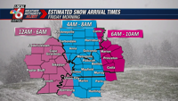
The snowstorm is anticipated to arrive from the west early on Friday, between midnight and sunrise. Residents should expect the heaviest snowfall in the morning and afternoon hours, with conditions tapering off by the evening. Commuters are advised to plan their travel accordingly as both morning and evening commutes could be notably impacted.
Forecast Details
- Accumulation: Snow will fall heavily at times, causing roads to become slick early Friday morning, with conditions worsening throughout the day. Expect snow-covered roads, especially secondary routes, which will remain a concern into the weekend.
- Temperature: The snow will accumulate rapidly due to recent low temperatures, which will remain below freezing during the event.
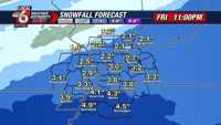
Affected Areas

A Winter Storm Watch is in place for areas including much of Western Kentucky, parts of Northwest Tennessee, and the Missouri Bootheel. These regions can expect snow totals ranging from 3 to 5 inches. Southern Illinois and Southeast Missouri should prepare for 1 to 3 inches, while counties along the Ohio River in Kentucky may see 2 to 4 inches.
Preparation and Precautions
- Residents are urged to keep an extra flashlight, food, and water in their vehicles during this period.
- Power outages are still impacting approximately 7,000 customers in Southern Illinois following an ice storm earlier in the week. Prepare for extreme cold, especially on Thursday morning when temperatures are expected to drop into single digits.
- Stay updated by downloading the WPSD Radar app to monitor the latest forecasts and warnings.
Potential for Escalation
Weather conditions are continuously being monitored, with the potential for Winter Storm Warnings to be declared as the situation develops. Areas with lower expected snowfalls could receive a Winter Weather Advisory. The forecast is highly confident, though minor adjustments in snow accumulation amounts may be made closer to the event.
Contact and Resources
For the latest updates and emergency information, contact WPSD Local 6:
- Address: 100 Television Lane, Paducah, KY 42003
- Phone: 270-415-1900
- Email: newstip@wpsdlocal6.com
- Stay connected through WPSD Local 6’s social media channels and mobile apps:
- iOS App
- Android App
By staying informed and prepared, you can ensure safety amid the challenging weather conditions anticipated this Friday. Remember to follow the recommended precautions and stay updated with the latest weather authority alerts.
Source: https://www.wpsdlocal6.com/news/weather-authority-alert-for-accumulating-snow-and-travel-impacts-on-friday/article_cdfe4ff6-cdd3-11ef-843a-2bd8a902193d.html