Tropical Depression Nine may become Imelda later today, coastal North Carolina impacts likely
How did your country report this? Share your view in the comments.
Diverging Reports Breakdown
Tropical Depression Nine may become Imelda later today, coastal North Carolina impacts likely
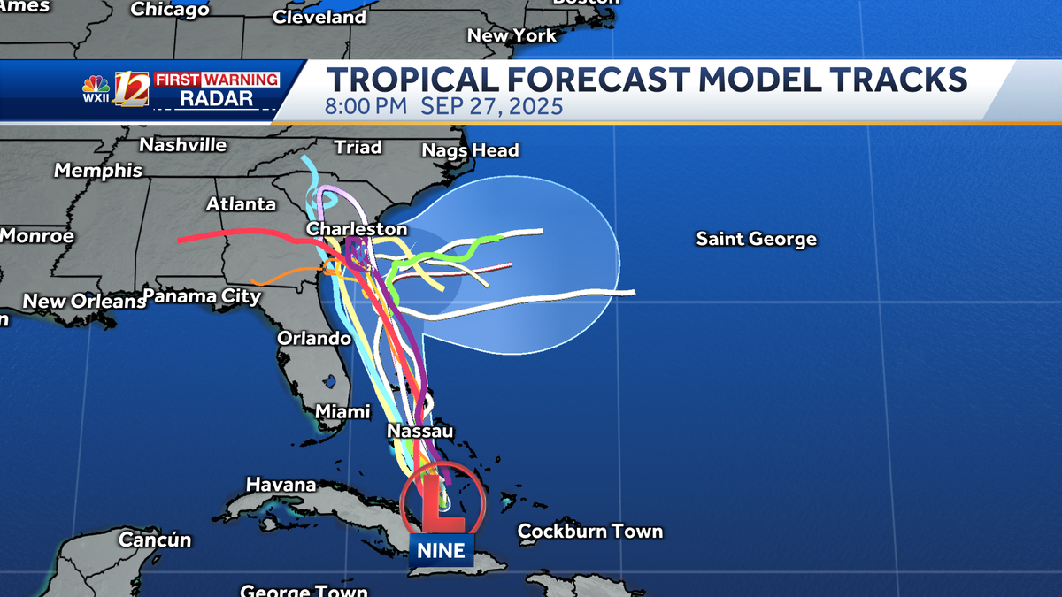
Tropical Depression Nine moves north along the East Coast with Hurricane Humberto nearby. The two systems are going to be CLOSE TOGETHER, so we may see a CENTRAL PRESSURE FORM right in the MIDDLE of the ATLANTIC to HELP STEER THIS SYSTEM A LITTLE BIT FARTHER AWAY FROM THE COAST, AND SOONER. We’re looking at just DANGEROUS CONDITIONS, SO A LOT OF CRUISE SHIPS ARE NOT GOING TO BE ABLE TO TRAVEL BACK AND FORTH OVER THE ATLANTic. OVER MOST OF THIS WEEK, WE COULD SEE LINGERING IMPACTS AS LONG AS THURSDAY AND FRIDAY. NOW THE EUROPEAN MODEL WITH THIS LATEST TRACK STILL SHOWS SOME OF THE HEAVIER RAINS RIGHT NEAR THE COast OR JUST OFF the COAST. AND NOTICE WE STILL HAVE SOME SHOWERS INLAND TOO, ANYWHERE FROM 1 TO 2IN COULD FALL FROM SOME OF THESE SHOWERS AND THUNDERSTORMS.
BETTER OPPORTUNITY TO SEE SHOWERS AND STORMS. HUMBERTO, A POWERFUL CATEGORY FIVE HURRICANE. IT’S AN IMMENSE STORM. IT’S MORE THAN SEVERAL HUNDRED MILES ACROSS. MORE THAN 500, IN FACT. AND WE SEE THIS ONLY ABOUT 800 MILES AWAY FROM WHAT IS TROPICAL DEPRESSION NINE. AND BECAUSE OF THAT IT MAY HELP TO STEER THE STORM, FORTUNATELY AWAY FROM THE COAST. AS WE GET YOU INTO THE NEXT COUPLE OF DAYS. SO THAT’S WHAT WE LIKE TO HEAR. IT’S NOT GREAT NEWS, THOUGH, FOR FLORIDA, THE BAHAMAS, WHERE WE SEE THIS MOVING REALLY JUST DRIFTING NORTHWESTERLY AT TWO MILES AN HOUR. THAT’S A SLOW MOVEMENT ON THE STORM. WE’RE GOING TO SEE THIS LIFT IN, THOUGH, AS WE LOOK AHEAD TO THE NORTHWEST. MEANTIME, THIS ONE’S GOING TO MOVE NORTHWEST FOR JUST A LITTLE WHILE LONGER. IT’S A LITTLE FASTER TONIGHT AT 13 MILES AN HOUR. STILL A CATEGORY FIVE STORM WITH GUSTS AT 195 MILES AN HOUR. IT TAKES A TURN AROUND BERMUDA. AND AS IT’S TAKING THAT, TURN AROUND BERMUDA, BECAUSE THESE TWO SYSTEMS ARE GOING TO BE CLOSE TOGETHER, WE MAY SEE A CENTRAL PRESSURE FORM RIGHT IN THE MIDDLE OF THE ATLANTIC TO HELP STEER THIS SYSTEM A LITTLE BIT FARTHER AWAY FROM THE COAST, AND SOONER, WHICH WOULD BE REALLY NICE. BUT IT DOES BECOME A CATEGORY ONE HURRICANE ON THIS FORECAST TRACK. BY EARLY MONDAY MORNING. IT TURNS AROUND TUESDAY INTO YOUR TUESDAY EVENING OFF THE COAST OF SOUTH CAROLINA. AND WITH THAT, IT COULD STILL BRING IN LOTS OF HEAVY RAIN. COASTAL SURF CONCERNS. WE’RE LOOKING AT JUST DANGEROUS CONDITIONS, SO A LOT OF CRUISE SHIPS ARE NOT GOING TO BE ABLE TO TRAVEL BACK AND FORTH OVER THE ATLANTIC. OVER MOST OF THIS WEEK, WE COULD SEE LINGERING IMPACTS AS LONG AS THURSDAY AND FRIDAY. NOW SOME OF OUR RAINFALL TOTALS A LITTLE BIT DIFFERENT. NOW THE EUROPEAN MODEL WITH THIS LATEST TRACK STILL SHOWS SOME OF THE HEAVIER RAINS RIGHT NEAR THE COAST OR JUST OFF THE COAST. YESTERDAY WE HAD JUST SO MUCH RAIN INLAND AND TODAY THE TRACK BEING FARTHER SOUTH AND EAST IS A GOOD THING. WILMINGTON THOUGH STILL MORE THAN SEVEN INCHES ABOUT 8.5IN, IF NOT MORE IN OAK ISLAND ON THIS CURRENT FORECAST TRACK, AT LEAST BY THE EUROPEAN MODEL. AND NOTICE WE STILL HAVE SOME SHOWERS INLAND TOO, ANYWHERE FROM 1 TO 2IN COULD FALL FROM SOME OF THESE SHOWERS AND THUNDERSTORMS. IN ADDITION TO THE FRONTS THAT WE’LL HAVE DEALING GETTING GOING LATER IN THE WEEK TO NOW, SHOWERS AND THUNDERSTORMS FOR FOLKS AS WE LOOK AHEAD FOR THE GFS MODEL, SHOWING US A LITTLE BIT MORE SHOWER ACTION FOR FOLKS UP TO THE NORTH THROUGH EMERALD ISLE AND HEADING UP TO GREENVILLE, BUT WE’RE LOOKING AT ANYWHERE FROM 8 TO 10IN AND SUGGESTING MAYBE 12IN AT OAK ISLAND. SO VARIATIONS OF THE FORECAST MODELS ARE STILL GOING TO HAPPEN, AND THERE IS NO GUARANTEE IT WILL STAY OFF THE COAST. BUT RIGHT NOW, GIVEN THE FORWARD MOTION AND WHAT WE’RE SEEING WITH HUMBERTO, IT’S LOOKING GOOD TO HOPEFULLY SEE THE SYSTEM PULL AWAY FROM THE COAST A LITTLE SOONER. AND WE’VE GOT MORE THAN 4.5IN AS WE LOOK AHEAD FOR THIS EUROPEAN MODEL HERE FOR FAYETTEVILLE TO NEAR 11IN AT ATLANTIC BEACH, AS WE TAKE IT ALL THE WAY OUT THROUGH NEXT SATURDAY AND SHOWERS AND STORM CHANCES WILL BE WITH US BACK INTO THE MOUNTAINS. BUT THE GOOD NEWS IS, FOR FOLKS IN THE HIGH COUNTRY, IT DOES LOOK LIKE IT’S A MUCH BETTER SCENARIO THAN WHAT WE COULD HAVE IMAGINED. NOT A GREAT SCENARIO FOR FOLKS AT THE COAST THOUGH. A LOT OF URBAN FLOODING, FLASH FLOODING CONCERNS. THOSE WILL BE REAL BIG ISSUES AS WE MOVE FORWARD. AND LOOKING AT THAT CENTER OF THE STORM, STARTING TO TRY AND TAKE THIS SYSTEM HERE WITH MORE OF THAT FUJIWARA IMPACT, TRYING TO PULL IT AWAY. AND WE’RE LOOKING AT THAT MOVEMENT OF THE STORM, A CATEGORY ONE HURRICANE JUST OFF THE COAST OF THE CAROLINAS. IT COULD STILL BRING IN WINDS AND LOTS OF HEAVY RAIN AT THE BEACHES, AND UNFORTUNATELY, IF IT LINGERS ANY LONGER THAN THAT, WE COULD SEE EVEN MORE IMPACTS FOR OUR RIVERS TOO. SO WE’LL BE WATCHING FOR ALL OF THESE TRENDS AS WE LOOK AHEAD THROUGHOUT THE WEEK. AND SOME OF THAT ENERGY MAY LINGER ALONG THE COAST AS IT’S ABSORBE INTO A FRONT THAT WILL MOVE THROUGH GUSTS FOR WINDS ANYWHERE FROM 20 TO 40 MILES AN HOUR, UP TO 50. AS THIS SYSTEM NEARS AND STILL STAYS OFF THE COAST. SO WE HAVE TO WATCH FOR THAT. IT COULD HAVE BIG IMPACTS FOR US. STILL, A LOT OF FORECAST CHALLENGES FOR YOU, AND WE’LL TALK MORE ABOUT THE SYSTEM AS WE GET YOU THROUGH THE WEEK. WE HAVE THE SEVEN DAY FORECAST THOUGH, WITH TROPICAL IMPACTS POSSIBLE ON YOUR TUESDAY AND EVEN YOUR MONDAY, WE COULD SEE SOME HEAVY RAINS AND ROUNDS OF SHOWERS.
Advertisement Tropical Depression Nine may become Imelda later today, coastal North Carolina impacts likely Take a look at the twin tropical systems in the tropics and view latest models, maps and tracks as Tropical Depression Nine moves north along the East Coast with Hurricane Humberto nearby. Editorial Standards ⓘ
Tropical Depression Nine is moving very slowly at about 3 mph to the northwest over The Bahamas. As Nine continues slowly drifting over the region, it will bring torrential tropical rainfall to The Bahamas, Cuba and may bring tropical storm-force winds to Florida’s East Coast. Georgia, South Carolina and North Carolina residents will want to monitor this storm as heavy coastal rain is likely and track changes with higher inland impact may still develop.Tropical Storm Warnings in FloridaThe National Hurricane Center meteorologists are issuing tropical advisories on Nine and Hurricane Humberto. You can also find tropical advisories in Spanish here for T.D. Nine. Advisories for the massive Hurricane Humberto can be found here; Hurricane Humberto advisories in Spanish can be found here.From Florida to South Carolina, rainfall up to six inches is possible now through Tuesday. Although track uncertainty remains, heavy rain ahead of future Imelda may develop Monday and continue through early Thursday with 10 to 12 inch totals possible along the southern coast of North Carolina. Periods of scattered showers and storms may bring up to two inch totals for the Eastern Piedmont Triad.Tropical Depression Nine rainbands seen from Puerto Rico Nine is slow to progress, track offshore of Carolinas nowTropical Depression Nine is projected to become Tropical Storm Imelda and eventually a Category 1 hurricane; North Carolina inland impacts are lower on the current track for now, but high impacts to the coastal Carolinas are expected as the storm may linger over the warm Gulf Stream current. Nine is much slower in forward speed and growth than original forecast projections therefore, National Hurricane Center meteorologists believe a faster turn to the east may occur. This is a better scenario than earlier forecast tracks for the High Country of North Carolina where residents were concerned for flooding again from a tropical system so close to the date of Helene’s destruction last year, Sept. 26.Nine may become Tropical Storm Imelda as it moves parallel to the Florida Coastline.By Monday evening Imelda may become a Category 1 HurricaneBy Tuesday evening Hurricane Imelda begins moving east-northeast toward Bermuda.On Wednesday evening it may remain a Category 1 hurricane offshore southeast of Wilmington.On Thursday evening the storm may roll farther away from the Outer Banks and continue east toward Bermuda as it weakens.The latest official track has the storm remaining just offshore of South Carolina and Georgia while turning east instead of north toward North Carolina. There is still a risk heavy rainfall that may bring life-threatening flooding to North Carolina beaches from Monday through Wednesday.Complex weather patternThere is a great deal of complexity in the forecast given the juxtaposition of two tropical systems in close proximity; this lends to lower confidence in tropical tracks beyond 48 hours. Tropical Advisory: Tropical Depression Nine and Hurricane HumbertoTropical Tracks: Humberto and Tropical Depression NineTropical Spaghetti Model Plots: Humberto and Tropical Depression NineSlideshow: Check out looping satellites and forecast models National Hurricane Center meteorologists are issuing advisories on Tropical Depression Nine and Hurricane Humberto, and the National Oceanic and Atmospheric Administration have Hurricane Hunters crews flying into the storms to gather more details.The Fujiwhara effect may develop and help steer future Imelda farther away from North CarolinaTropical Depression Nine and Hurricane Humberto are projected to move between the North Carolina coast and Bermuda. Imelda may ride over the Gulf Stream and influence Humberto’s journey too over the Atlantic. The twin tropical systems may interact with one another and change storm intensities as well as tracks when they approach the Southeast U.S. coast early this coming week. For more about the Fujiwhara effect that occurs when two tropical cyclones are close enough to one another, read Meteorologist Michelle Kennedy’s story here.Forecast ChallengesWe expect a lot of updates to the forecast once Tropical Depression Nine becomes Imelda. This is expected to happen between now and Sunday evening. There are several forecast challenges as we monitor the tropics through the weekend. Challenges include: What happens with the steering currents aloft How much wind shear may impact Nine? What will Humberto’s intensity and forward movement be as Imelda forms from Tropical Depression Nine? Could a surface boundary and a ridge of high pressure keep Imelda near North Carolina’s coast longer and produce more rainfall?Humbertos swells may reach the Carolinas on MondayThere is a lot of uncertainty about whether Nine or future Hurricane Imelda will be close enough to the North Carolina coast to bring major impacts since the storm track is farther south and east than earlier Saturday. However, coastal impacts from big waves and rip currents are already developing as swells will reach shores in the Carolinas by Monday. Click here for more about tropical impacts expected in North Carolina, maps, models and beach forecasts..Hurricane Humberto becomes second Category 5 hurricane of the 2025 seasonHumberto became a powerful Category 5 hurricane over the open Atlantic on Saturday afternoon with hurricane-force winds of 160 mph extending out 25 miles from the center of the storm and tropical storm-force winds extend 125 miles from the eye. The hurricane is on a west-northwest track moving at 13 mph while Tropical Depression Nine is drifting north at 2 mph. Nine is forecast to become Tropical Storm Imelda sometime on Sunday. Areas to Watch in the TropicsOver the next few weeks, the WXII 12 First Warning Weather Team will be focused on three main areas for tropical development:The Gulf: Very warm sea surface temperatures can help fledgling storms explode into monster hurricanes quickly under the right atmospheric conditions.Africa: In late summer, waves of low pressure often move from the Sahara Desert into the eastern Atlantic. They can develop into tropical systems over time. The sub-tropical high-pressure system over the Atlantic will often steer these systems through the tropical Atlantic towards Central America and the United States.Southeast U.S. Coast: Weaker, short-lived storms often form in late summer or fall along the old frontal boundaries. Areas of offshore low pressure can become tropical. These storms can become dangerous quickly because they are so close to the coast.Are you prepared for inland tropical impacts in North Carolina and Virginia?September and October are historically the busiest tropical months for the Carolinas. The 2025 Atlantic hurricane season continues through Nov. 30.Piedmont Triad residents can stay alert, informed and prepared:Know your evacuation routes and have an emergency plan.Monitor the forecasts on WXII 12 News or WXII12.com.Review insurance coverage and protect important documents, especially in light of past flooding events like Helene (2024) and Chantal (2025).Have an emergency preparedness kit: water, batteries, flashlights, and medications in case of power loss.WXII INTERACTIVE STUDIO: EXPLORE MORELanie Pope explains Helene’s massive flooding, why it was potentially a 100-year flood event for the state in the interactive video featured below:It’s the worst of the worst to ever hit North Carolina, as Dylan Hudler explains the names our state will never forget in the interactive video featured below:It’s not just the coast that gets hit with devastating impacts from hurricanes, as Brian Slocum explains, why monster storms leave lasting impacts in the interactive video featured below:Hurricane Hugo brought massive devastation to the Carolinas, as Dave Aiken explains with an in-depth look at the disastrous storm in the interactive video featured below.Find out the best ways to prepare for hurricane season as Michelle Kennedy explains what you can do now instead of waiting to do later in the interactive video featured below:More weather coverage: Weather Alerts | Closing and delays | Latest weather forecast | Post pictures to the uLocal North Carolina Facebook Group | Traffic information | Report closings and delays | SkyCams | Download the WXII12 News mobile app