Omaha weather: Dangerous heat this weekend
How did your country report this? Share your view in the comments.
Diverging Reports Breakdown
Hot and breezy Sunday; storm chances increase Monday
Sunday, another day with temperatures in the 90s with south winds gusting up to 45 mph. A Heat Advisory (Orange) and an Extreme Heat Warning (Pink) are still in place through Sunday night. A cold front will move through Sunday afternoon and evening, which will develop storms out west by the early evening. These storms will have gusty winds up to 70 mph, large hail up to ping pong balls and a few brief spin up tornadoes as the storms begin to develop. Monday, temperatures staying warm in the 80s and 90s. Scattered storms will develop in the mid afternoon and intensify by Monday evening and Monday night. The storm chances will continue through the week, with temperatures staying close to average in the 70s and 80s.
Sunday, high temperatures getting into the mid to upper 90s, with south winds still gusting up to 40 mph.
Sunday, feel like temperatures will be near 105 degrees for most of us in SE Nebraska.
South winds will continue to gust to around 40+ mph throughout your Sunday.
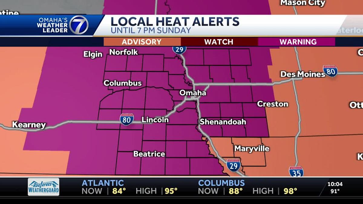
A Heat Advisory (Orange) and an Extreme Heat Warning (Pink) are still in place through Sunday night.
Heat Advisory: Dangerous heat conditions possible. Consider postponing any outdoor plans and drink plenty of water. Heat illnesses will be more likely, particularly for sensitive groups.
Dangerous heat conditions possible. Consider postponing any outdoor plans and drink plenty of water. Heat illnesses will be more likely, particularly for sensitive groups. Extreme Heat Warning: Dangerous heat conditions are in progress. Hydrate, limit extended times outdoors and in direct sunlight. Heat illnesses are possible for all groups if proper precautions are not taken.
StormCast shows some isolated storm develop by Sunday evening near Cherry county and O’Neil. These isolated storms will have the best chance for large hail and a few brief spin up tornadoes. These storms will mostly stay NE of Lincoln and Omaha through Sunday night.
Sunday afternoon and evening, a SLIGHT risk for severe weather is in place across central Nebraska and a MARGINAL risk for surrounding areas. Main threats will be damaging winds up to 70+ mph, large hail up to ping pong balls and a few brief spin up tornadoes . The heating of the day will help fuel storm chances across the region, as temperatures will warm up into the 90s. There will be a bit of cap in place, but a cold front will help develop storms along or ahead of the front Sunday evening.
Winds up to 70+ mph will be possible.
Hail up to ping pong balls will be possible with the beginner storms Sunday evening.
A few brief spin ups will be possible with any single cells that do develop ahead of the front.
Monday, a MARGINAL risk for severe weather is in place for much of the state. Scattered storms will develop in the mid afternoon and intensify by Monday evening and Monday night. The main concerns will be damaging winds, large hail and a few weak tornadoes possible.
Monday evening, scattered storms develop across the region. The bulk of the storms will mostly be in eastern and SE Nebraska through Monday night.
Sunday, another day with temperatures in the 90s with south winds gusting up to 45 mph. A cold front will move through Sunday afternoon and evening, which will develop storms out west by the early evening. These storms will have gusty winds up to 70 mph, large hail up to ping pong balls and a few brief spin up tornadoes as the storms begin to develop. Monday, temperatures staying warm in the 80s and 90s with storms likely by Monday afternoon and evening. These scattered storms could have all the severe concerns. The storm chances will continue through the week, with temperatures staying close to average in the 80s.
Meteorologist Houston Hall
Facebook: HHallWX
Northeast, Midwest Heat Wave Could Smash Records
A dangerous, widespread heat wave will bake the central and eastern U.S. Highs in the 90s will spread over much of the country east of the Rockies, except for the far northern tier. Dozens of locations, especially in the Northeast, will be within striking distance of daily record highs. The heat index will be in the triple digits on one or more days for some cities in the Midwest and Northeast this weekend into early next week. The National Weather Service has already issued extreme heat watches, warnings and heat advisories for large swaths of the central, eastern United States. The highest level heat alerts are now called “extreme heat” watches and warnings. The combination of heat and humidity could be dangerous for those without access to air conditioning, especially those with chronic illness, the CDC says. The “extreme” level of heat is defined as “re/re/ra/ra” or “ra/re” heat, defined as long and extremely hot or very hot, with a heat index of at least 100.
A dangerous, widespread heat wave will bake the central and eastern U.S., bringing the hottest temperatures of the year and uncomfortably muggy air to the Midwest and Northeast that in some areas could last into much of next week.
Already, daily record highs were set Thursday in Salt Lake City (104 degrees), their first triple-digit high of the year.
(MORE: Download The Weather Channel App To Track The Heat Dome)
Here are the main takeaways from the forecast:
Heat Alerts
– The National Weather Service has already issued extreme heat watches, warnings and heat advisories for large swaths of the central and eastern U.S., as you can see in the map below. Some cities in these alerts, including Omaha, the Twin Cities, Chicago, Kansas City, St. Louis, Detroit, Cincinnati, Pittsburgh, Philadelphia and New York City.
– The highest level heat alerts are now called “extreme heat” watches and warnings. You can find more about those changes here. These alerts indicate that heat illnesses are expected to spike when they are in effect. Minneapolis and Omaha are just two of the cities that are already expected to see dangerous conditions.
(TRACK THE HEAT: Temperatures | Heat Index)
Heat Timing
Here’s when we expect the worst of the heat:
– Plains and upper Mississippi Valley: Lasting through Sunday
– Rest of Mississippi Valley: Could last through much of next week
– Rest of Midwest: Relief will arrive by Tuesday in the northern Great Lakes, but heat could last much of next week in the Ohio Valley
– Northeast: Ramps up Sunday, with some relief in New England, eastern Great Lakes by Wednesday. Mid-Atlantic and Appalachians heat could last much of next week
(MAPS: 10-Day Forecast US Highs/Lows)
How Hot?
– Highs in the 90s will spread over much of the country east of the Rockies, except for the far northern tier.
– Dozens of locations, especially in the Northeast, will be within striking distance of daily record highs, especially Sunday through Tuesday.
– A few locations could approach or top 100 degrees during the heat wave. Boston, New York City, Philadelphia and Washington, D.C. could flirt with the century mark during the peak of the heat wave next week. Some of those locations could do so multiple days during the heat wave.
– Omaha is hosting the College World Series this weekend. Highs there will push 100 degrees both Saturday and Sunday. Sunday’s game between LSU and Coastal Carolina could be a scorcher. Temperatures will warm closer to 100 during Sunday afternoon’s game.
– New York’s Central Park hasn’t reached 100 degrees since July 18, 2012, according to the National Weather Service. Philadelphia hasn’t reached 100 degrees in June since 1994. Boston’s last 100-degree high was on July 24, 2022.
Forecast Highs Next Week
Humid, Too
– Oppressive humidity will accompany the heat wave.
– This will particularly be the case in the mid-Mississippi and Ohio Valleys, but also into the upper Mississippi Valley, Great Lakes and at least parts of the mid-Atlantic and Northeast.
– That means the heat index, or feels-like temperature, will be in the triple digits on one or more days for some cities in the Midwest and Northeast this weekend into early next week.
– This also means that overnight temperatures will not cool off or provide any relief from the daily heat.
(MORE: Why The Dew Point Temperature Matters)
Forecast Dew Point (This map depicts where the muggiest air is expected in the central and eastern U.S. The higher the dew point, the more humid the air. In general, dew points of 70 degrees or higher are very humid. )
What You Should Do
– Heat is the number one weather killer in the U.S., with hundreds of fatalities each year.
– The combination of heat and humidity lingering into the night for several days in a row could be dangerous for those without access to air conditioning, especially in the cores of larger cities.
– Check on family, friends, the elderly and those with chronic illness who live without access to air conditioning.
– If possible, avoid being outdoors for long in the peak heat of the afternoon.
– If not, take frequent breaks, avoid strenuous activity, drink more water than usual and wear loose, lightweight clothing.
(MORE: Heat Advice From An ER Doctor)
This map shows the National Weather Service Heat Risk forecast, an experimental index developed with the CDC to quantify potential impacts of excessive heat. The “extreme” level of impact is defined as “rare and/or long-duration extreme heat with little to no overnight relief that affects anyone without effective cooling and/or adequate hydration.”
This map shows the National Weather Service Heat Risk forecast, an experimental index developed with the CDC to quantify potential impacts of excessive heat. The “extreme” level of impact is defined as “rare and/or long-duration extreme heat with little to no overnight relief that affects anyone without effective cooling and/or adequate hydration.”
Why So Hot?
– This heat wave will be triggered by a change in the jet stream pattern.
– Specifically, a strong bubble of high pressure aloft known as a heat dome will develop over the eastern U.S.
– Sinking air near the center of this heat dome suppresses clouds, allowing the intense sunshine this time of year to heat the ground and air above it most efficiently.
– Southerly and southwesterly winds will also tap hot and humid air from the South into the Midwest and Northeast.
– This heat dome will only slowly weaken and “flatten out” in the East in the week ahead.
The pattern triggering the heat wave features a “heat dome” of high pressure over the eastern U.S.
Jonathan Erdman is a senior meteorologist at weather.com and has been covering national and international weather since 1996. Extreme and bizarre weather are his favorite topics. Reach out to him on Bluesky, X (formerly Twitter) and Facebook.
First Alert 6 Weather Day: Dangerous heat continues Sunday, relief comes Monday
Tonight will be another steamy one with mostly clear skies and windy conditions. Lows will fall to the lower 80s with heat index in the mid to upper 80s. Highs will reach back into the triple digits around 100°. Heat index could reach up to 108° with gusty winds from the south reaching 50 mph. Monday is still a First Alert 6 Weather Day for the potential of severe thunderstorms in the early morning and mainly the mid-to-late afternoon hours.
Another warm and muggy night ahead with clear skies. (wowt)
Sunday is still a First Alert 6 Weather Day as the heat stretch continues. Highs will reach back into the triple digits around 100°. Heat index could reach up to 108° with gusty winds from the south reaching 50 mph.
First Alert 6 Weather Days continue through Sunday and Monday for heat and storms. (wowt)
Sunday will be another hot and humid day. (wowt)
Sunday will be just as hot with heat index up to 108° possible. (wowt)
The Extreme Heat Advisory continues for the metro until 7 PM Sunday night.
Extreme Heat Warning continues for most of the area until 7 PM Sunday night. (wowt)
For the second game of the College World Series between LSU vs Coastal Carolina, it’s going to be hot and humid again with heat index likely in the triple digits for most of the game.
LSU vs Coastal Carolina Game 2 Forecast (wowt)
By Monday, we start cooling down as a cold front moves over Nebraska. Highs continue on trending cooler down into the upper 80s and lower 90s with heat index in the mid to upper 90s.
Monday is still a First Alert 6 Weather Day for the potential of severe thunderstorms in the early morning and mainly the mid to late afternoon hours. The cold front will produce isolated thunderstorms around sunrise Monday morning then diminish off by mid morning before becoming scattered by the afternoon.
Some storms may produce quarter-size hail and damaging winds reaching 60 mph. If we get heavy downpours, there could be some minor flooding. The tornado risk is low.
A Marginal risk has been issued for the area late Sunday night and Monday afternoon.
Isolated t-storms look to form overnight into early Monday morning. (wowt)
A chance of strong storms are possible Monday afternoon. (wowt)
After the storms, we will back to near normal in the 80s and 90s for the rest of the week with moderate to high humidity.
Copyright 2025 WOWT. All rights reserved.
Heat relief arrives early in the workweek with storms
The record high in Omaha for June 22 is 100, which was set in 1930. The humidity will easily push the heat index closer to 105. The cold front will also fire off numerous showers and storms, especially in the second half of the day. It’s uncertain exactly how long it will take the front to fully push out of the region, but it could be gone as early as Friday. If we fully dry out into the weekend, we could get back to 90 on Saturday. The possibility for a faster cold front would keep the best chances for rain along and south of I-80. A slower front would bring better rain farther northwest.
After a warm start to Sunday, near 80 degrees, near-record heat is expected in the afternoon. The record high in Omaha for June 22 is 100, which was set in 1930. We likely fall just shy of that. The humidity will easily push the heat index closer to 105. We also stay mostly sunny and windy throughout the day.
Then, a cold front will start to approach the area from the northwest, and it could push a couple isolated and strong storms at areas northwest of Omaha late Sunday night.
Before the cold front arrives in our area Monday, we likely have enough time to hit 90 degrees. The cooler air will reach northeast Nebraska first, keeping some spots there in the 70s! If the cold front speeds up, Omaha may only hit the mid 80s. The cold front will also fire off numerous showers and storms, especially in the second half of the day. The possibility for a faster cold front would keep the best chances for rain along and south of I-80. A slower front would bring better rain farther northwest. A couple of these storms could be strong enough to produce pockets of hail and strong wind.
The cold front will then stall across eastern Nebraska and western Iowa, and it will trigger more rounds of scattered showers and storms through the rest of the workweek.
A lot of us will see those showers and storms again Tuesday. Those that stay dry long enough will warm into the mid 80s.
About half of the region will see more rain Wednesday and Thursday as scattered showers and storms continue at times. This keeps highs in the 80s.
It’s uncertain exactly how long it will take the front to fully push out of the region, but it could be gone as early as Friday. For now, we’ll lower the threat for showers and storms Friday and Saturday, but we’re keeping them around just in case the front gets stubborn.
If we fully dry out into the weekend, we could get back to 90 on Saturday.
SUNDAY
Mostly Sunny
Windy
High: 99
Heat Index: 105
SUNDAY NIGHT
Mostly Clear
Isolated Storms
Low: 77
MONDAY
Mostly Cloudy
Rain & Storms
High: 90
TUESDAY
Mostly Cloudy
Rain & Storms
High: 86
Share your weather pictures with KMTV:
Life-threatening heat dome spreading across 30 states after setting records in Plains
The sprawling area of high pressure began scorching the Plains Thursday and Friday, breaking several heat records in Colorado, Rapid City, South Dakota and parts of Nebraska. Denver tied its record high of 99 degrees on Friday while Pueblo reached 103. The heat will spread across the Midwest and into the Great Lakes, where high temperatures will surge 10-20 degrees above average. By Sunday, more than 200 million Americans will see temperatures at or above 90 degrees with various heat alerts spanning from Colorado to Maine. High humidity with dew points reaching into the 70s if not near 80 degrees will make temperatures feel well over 100 degrees in cities like Chicago, Louisville, Cleveland and Raleigh.
The sprawling area of high pressure began scorching the Plains Thursday and Friday, breaking several heat records in Colorado, Rapid City, South Dakota and parts of Nebraska. Denver tied its record high of 99 degrees on Friday while Pueblo reached 103.
HUMID HEAT OR DRY HEAT: WHAT IS WORSE?
Heat alerts are in effect in the Plains through Sunday, with Duluth, Minnesota, Minneapolis, Sioux Falls, South Dakota and Omaha, Nebraska under extreme heat warnings.
HEAT KILLS MORE AMERICANS THAN FLOODING, TORNADOES, HURRICANES OR LIGHTNING
Dangerous heat spreads into the Northeast next week
As the heat dome spreads east, it’ll cast a wide net over more than half of the country, causing potentially life-threatening temperatures.
This weekend the heat will spread across the Midwest and into the Great Lakes, where high temperatures will surge 10-20 degrees above average.
By Sunday, more than 200 million Americans will see temperatures at or above 90 degrees with various heat alerts spanning from Colorado to Maine. High humidity with dew points reaching into the 70s if not near 80 degrees will make temperatures feel well over 100 degrees in cities like Chicago, Louisville, Cleveland, Nashville and Raleigh, according to the FOX Forecast Center.
The high humidity will also make for warm nights, offering very little relief from the extreme daytime temps.
In the Northeast, widespread heat alerts are in place through Wednesday as temperatures are forecast to soar to levels not always seen during the month of June.
Extreme Heat Warnings – the most dire heat alert from the National Weather Service – now stretch from Philadelphia up the Atlantic coast through New York City into Boston. Pittsburgh and parts of West Virginia are also under similar warnings so far.
Triple-digit temperatures are forecast in New York City, Washington, D.C., Philadelphia and Hartford, Connecticut on Tuesday.
New York City and Philadelphia have not hit 100 in any month since 2012. In New York City, the temperature had only reached 100 degrees in June three times prior, most recently on June 27, 1966. In Philadelphia, it has occurred 10 times before, most recently on June 15, 1994.
From the Gulf Coast to Massachusetts, heat indices will also top 100 degrees, making it dangerous for those working or playing outside without proper hydration or cooling options.
DOG’S RESCUE FROM CALIFORNIA TRAIL EMPHASIZES DANGER OF WARM-WEATHER HIKES FOR DOGS
Across the country, 30+ centuries-old heat records are threatened and likely to be broken by the end of next week.
HOW TO WATCH FOX WEATHER
The heat should abate some starting Wednesday, but it’ll still remain hot through the week as upper-level ridging remains in place.
Source: https://www.yahoo.com/news/omaha-weather-dangerous-heat-weekend-033509254.html