A potent heat dome is building over the US, sending temperatures into the triple digits
How did your country report this? Share your view in the comments.
Diverging Reports Breakdown
A potent heat dome is building over the US, sending temperatures into the triple digits
250 daily temperature records could be broken during the peak of the heat on Monday and Tuesday. Temperatures for some locations could be “the hottest observed in over a decade,” the National Weather Service says. A level 4-of-4 extreme heat risk is in place through at least Thursday, stretching from the Midwest to the Mid-Atlantic and including some parts of the Northeast. It will feel more like July, summer’s hottest month, than June for many locations as temperatures rise 15 to 20 degrees above normal. The heat will slowly start to ease on Wednesday, especially for some in the Midwest and New England, but Thursday will mark the true turn back toward more normal June warmth for many in the eastern half of the country. The last 100 degree high temperature in New York City occurred on July 18, 2012, according to the National Climatology Center. The city could reach 100 degrees on Tuesday – an intense threshold that hasn’t been recorded in June since 1966.
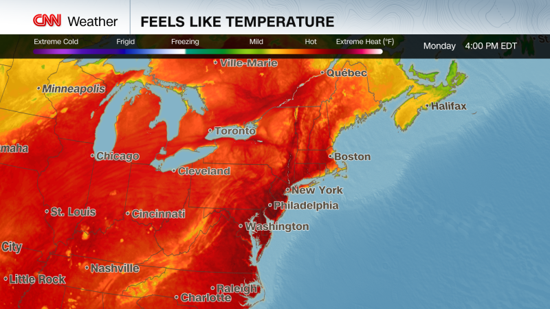
An extremely dangerous heat wave is underway for the eastern half of the United States as a potent heat dome reaches its peak, bringing the hottest temperatures of the year so far – the hottest in years for some cities – and putting tens of millions at risk.
Over 250 daily temperature records could be broken during the peak of the heat on Monday and Tuesday, including both record highs and record warm lows. Temperatures for some locations could be “the hottest observed in over a decade,” the National Weather Service in Mount Holly, New Jersey, warned. Additional records could fall Wednesday and Thursday.
Around 150 million people are under heat alerts Monday, according to the National Weather Service. It will feel more like July, summer’s hottest month, than June for many locations as temperatures rise 15 to 20 degrees above normal.
A level 4-of-4 extreme heat risk is in place through at least Thursday, stretching from the Midwest to the Mid-Atlantic and including some parts of the Northeast. This long-lasting heat is rare, will likely offer little to no overnight relief and will affect “anyone without effective cooling and/or adequate hydration,” the weather service cautions.
“Heat-related illnesses increase significantly during extreme heat and high humidity events,” the NWS warned, noting extreme heat can be life-threatening, especially for children, the elderly and people with pre-existing health conditions.
The dangerous impacts were immediate as sizzling conditions ramped up in the central US over the weekend. Multiple people, including a Major League Baseball player, an umpire and a staff member, were treated for heat-related illnesses Saturday when the Seattle Mariners faced off against the Chicago Cubs at Wrigley Field in Chicago. Temperatures spiked into the mid-90s during the game but humidity made it feel more like 105.
Heat remains the deadliest form of extreme weather in the US, and the frequency and longevity of extreme heat waves are on the rise in recent years due to human-caused climate change. Nighttime temperatures are taking the hardest hit from climate change, and are warming faster than daytime highs.
The hazardous heat spread into the East on Sunday and will reach a fever pitch Monday and Tuesday.
New York City could break its daily high temperature records Monday and Tuesday as temperatures soar into the mid-to-upper 90s. It could reach 100 degrees on Tuesday – an intense threshold that hasn’t been recorded in the city in June since 1966. The last 100 degree high temperature in New York City occurred on July 18, 2012.
A woman holds a fan during a heat wave in New York City, on Sunday. Kena Betancur/AFP/Getty Images
Other I-95 corridor cities will roast this week. Philadelphia will hover within a degree or two of 100 Monday through Wednesday, likely breaking its daily high temperature record three days in a row. Tuesday’s high of 101 degrees could come close to the hottest June day on record for the city and would mark the highest temperature recorded since 2012.
Washington, DC, will endure a trio of triple-digit days Monday through Wednesday, likely breaking multiple daily high temperature records along the way. The nation’s capital doesn’t typically record its first 100 degree day until mid-July.
Not even northern New England will escape the intense heat. Monday could be one of the three hottest June days on record for Burlington, Vermont, with a high in the upper 90s expected. The city – located fewer than 40 miles from the Canadian border – typically doesn’t see that happen until mid-July, if heat reaches that level at all.
Temperatures will slowly start to ease on Wednesday, especially for some in the Midwest and New England, but Thursday will mark the true turn back toward more normal June warmth for many in the eastern half of the country.
This early-season event is likely just a snippet of what’s to come.
For nearly the entire Lower 48 — excluding parts of Arizona, New Mexico and West Texas — the warmest days typically occur in July or August. Plus, a hotter than normal summer is expected for the entire Lower 48, according to forecasts from the Climate Prediction Center.
Source: https://www.cnn.com/2025/06/23/weather/heat-dome-midwest-east-coast-climate