Environmental conditions could end development for disturbance in Atlantic: NHC
How did your country report this? Share your view in the comments.
Diverging Reports Breakdown
Tropical Development Chances Near Southeast Coast Diminish, But Heavy Rain Threat Remains
The National Hurricane Center has been tracking an area off the Southeast coast for a chance of tropical or subtropical development the past few days. That chance has diminished to 0% since low pressure is expected to form inland over the Carolinas. Heavy rain will still be concern in spots despite the fact tropical or tropical development is not expected. The bulk of any heavy rain will stretch from southeast Georgia to the eastern Carolinas on Thursday and Thursday night.
What We Are Tracking
A weather disturbance that has already brought stormy conditions to Florida will spread toward the coastal Carolinas and the offshore waters of the Southeast coast through the end of the week.
The National Hurricane Center has been monitoring this system since Monday for a low chance that it could develop tropical or subtropical characteristics. In an update Wednesday morning the NHC said that chance has diminished to 0% since low pressure is expected to form inland over the Carolinas as opposed to over the waters off the Southeast coast.
Heavy rain will still be concern in spots despite the fact tropical or subtropical development is not expected.
Areas from Florida to the eastern Carolinas could see pockets of heavy rain through Wednesday night.
Advertisement On Thursday and Thursday night, the bulk of any heavy rain will stretch from southeast Georgia to the eastern Carolinas. That could include Savannah, Georgia; Charleston, South Carolina; and Wilmington, North Carolina.
Rainfall from this system will exit the Southeast coastline on Friday as the system moves east.
Beaches on the Southeast coast could also see choppy surf and a risk of rip currents, so take heed of warnings if you are headed to the beach.
Typical For This Time Of Year
This region is no stranger to tropical development for the month of June. Parts of the Caribbean, Gulf and Southeast coast are all common areas for development this time of year, as shown shaded in yellow below.
So the good news is, this is nothing out of the ordinary.
Caitlin Kaiser graduated from the Georgia Institute of Technology with both an undergraduate and graduate degree in Earth and Atmospheric Sciences before starting her career as a digital meteorologist with weather.com.
Tropical depression could form in Pacific by end of week: See tracker
The National Hurricane Center is tracking a disturbance in the Pacific it says could become a tropical depression by the end of the week. The National Oceanic and Atmospheric Administration released its prediction for the 2025 Atlantic hurricane season on Thursday, May 22. NOAA said to take the time now to write down your hurricane plan and share it with your family. The 2025 Pacific hurricane season began on May 15, the Atlantic season officially began on June 1 and will last through the endof November. The hurricane center said early Monday morning an area of low pressure is forecast to form offshore of the coast of Central America and southern Mexico during the middle to late portions of this week. NHC forecasters currently give the system a 40% chance of formation through the next seven days, the NHC said Monday, June 2. It does not illustrate the full width of the storm or its impacts, and the center is likely to travel outside the cone up to 33% of the time, it said. The storm is expected to move generally westward to west-northwestward.
The National Hurricane Center is tracking a disturbance in the Pacific it says could become a tropical depression by the end of the week.
The hurricane center said early Monday morning an area of low pressure is forecast to form offshore of the coast of Central America and southern Mexico during the middle to late portions of this week.
“Once it forms, the disturbance is expected to move generally westward to west-northwestward” and environmental conditions are expected to be “marginally conducive” for gradual development of this system, the NHC said Monday, June 2. “A tropical depression could form by the end of the week.”
NHC forecasters currently give the system a 40% chance of formation through the next seven days.
While the 2025 Pacific hurricane season began on May 15, the Atlantic season officially began on June 1 and will last through the end of November. Active hurricane weather typically peaks between mid-August and mid-October.
The National Oceanic and Atmospheric Administration released its prediction for the 2025 Atlantic hurricane season on Thursday, May 22, predicting an above-average season, with 13 to 19 named storms and six to 10 hurricanes.
Pacific storm tracker
This forecast track shows the most likely path of the center of the storm. It does not illustrate the full width of the storm or its impacts, and the center of the storm is likely to travel outside the cone up to 33% of the time.
How do hurricanes form?
Hurricanes are born in the tropics, above warm water. Clusters of thunderstorms can develop over the ocean when water temperatures exceed 80 degrees Fahrenheit. If conditions are right, the clusters swirl into a storm known as a tropical wave or tropical depression.
A tropical depression becomes a named tropical storm once its sustained wind speeds reaches 39 miles per hour. When its winds reach 74 mph, the storm officially becomes a hurricane.
Prepare now for hurricanes
Delaying potentially life-saving preparations could mean waiting until it’s too late. “Get your disaster supplies while the shelves are still stocked, and get that insurance checkup early, as flood insurance requires a 30-day waiting period,” NOAA recommends.
Prepare now for hurricanes: Here’s what you should do to stay safe before a storm arrives
Develop an evacuation plan : If you are at risk from hurricanes, you need an evacuation plan. Now is the time to begin planning where you would go and how you would get there.
: If you are at risk from hurricanes, you need an evacuation plan. Now is the time to begin planning where you would go and how you would get there. Assemble disaster supplies : Whether you’re evacuating or sheltering-in-place, you’re going to need supplies not just to get through the storm but for the potentially lengthy aftermath, NOAA said.
: Whether you’re evacuating or sheltering-in-place, you’re going to need supplies not just to get through the storm but for the potentially lengthy aftermath, NOAA said. Get an insurance checkup and document your possessions : Contact your insurance company or agent now and ask for an insurance check-up to make sure you have enough insurance to repair or even replace your home and/or belongings. Remember, home and renters insurance doesn’t cover flooding, so you’ll need a separate policy for it. Flood insurance is available through your company, agent, or the National Flood Insurance Program. Act now, as flood insurance requires a 30-day waiting period.
: Contact your insurance company or agent now and ask for an insurance check-up to make sure you have enough insurance to repair or even replace your home and/or belongings. Remember, home and renters insurance doesn’t cover flooding, so you’ll need a separate policy for it. Flood insurance is available through your company, agent, or the National Flood Insurance Program. Act now, as flood insurance requires a 30-day waiting period. Create a family communication plan : NOAA said to take the time now to write down your hurricane plan, and share it with your family. Determine family meeting places, and make sure to include an out-of-town location in case of evacuation.
: NOAA said to take the time now to write down your hurricane plan, and share it with your family. Determine family meeting places, and make sure to include an out-of-town location in case of evacuation. Strengthen your home: Now is the time to improve your home’s ability to withstand hurricane impacts. Trim trees; install storm shutters, accordion shutters, and/or impact glass; seal outside wall openings.
Gabe Hauari is a national trending news reporter at USA TODAY. You can follow him on X @GabeHauari or email him at Gdhauari@gannett.com.
National Hurricane Center tracking disturbance, wave in the Caribbean
AccuWeather forecasters issued a high risk of potential tropical development over the next week. A broad area of low pressure will likely form over the southwestern Caribbean Sea in a few days with a growing chance of development late this week. The next named storm of the Atlantic Hurricane season will be Sara. The Atlantic hurricane season runs from June 1 through Nov. 30. The National Hurricane Center does not issue tropical advisories until a there is a named storm, but there is an exception for Sara. A tropical depression could form in the western Caribbean Sea or this weekend while meandering over the west Caribbean Sea. The western and central part of the Caribbean Sea will be conducive for tropical depression and storm formation, AccuWeather says. Some or most of the rest will be drawn northward into the central Gulf Coast region this week to bring downpours to Louisiana, Alabama and parts of Georgia. The remnants of Rafael are expected to dissipate by Tuesday night.
Maybe not. According to National Hurricane Center forecasters, a broad area of low pressure will likely form over the southwestern Caribbean Sea in a few days with a growing chance of development late this week, and they’re tracking a tropical wave in the central Caribbean that’s bringing heavy showers and thunderstorms across Puerto Rico and Hispaniola. More showers are hitting the southwest and far northwest Caribbean.
AccuWeather forecasters issued a high risk of potential tropical development over the next week.
“Get ready for Sara. We expect the next tropical storm to develop in the Caribbean this week,” said AccuWeather meteorologist Bernie Rayno. “The development process is already underway. There are showers and thunderstorms around Hispaniola that will move west. The storms will get a boost on Wednesday when wind shear starts to fade away. A front will provide more upward motion by midweek, helping these storms organize.”
Some moisture from Rafael joined a slow-moving front to dump 1 to 8 inches of rain in parts of eastern Texas and Louisiana Sunday. Some or most of the rest will be drawn northward into the central Gulf Coast region this week to bring downpours to Louisiana, Alabama and parts of Georgia, AccuWeather meteorologist Grady Gilman said, as part of a cold front moving over the lower Mississippi Valley.
But the season isn’t over yet.
“Once again, just as with Rafael most recently, the western and central part of the Caribbean Sea will be conducive for tropical depression and storm formation, provided that moisture increases over the region, wind shear remains low and there is a clustering of showers and thunderstorms in the first place,” AccuWeather said, adding that the zone of wind shear north of the Caribbean that has been blocking development could dissolve during the third week of the month.
The remnants of Rafael are expected to dissipate by Tuesday night as it continues to meanders around the Gulf.
➤ Weather alerts via text: Sign up to get updates about current storms and weather events by location
The next named storm of the Atlantic Hurricane season will be Sara.
Here’s the latest update from the NHC as of 1 p.m. EST Monday, Nov. 11:
National Hurricane Center map: What else is out there and how likely are they to strengthen?
Systems currently being monitored by the National Hurricane Center include:
Central and Western Caribbean Sea: An area of disorganized showers and thunderstorms to the south of Hispaniola over the central Caribbean Sea is associated with a tropical wave. This system is expected to move slowly westward during the next few days, and environmental conditions appear conducive for gradual development.
A tropical depression could form late this week or this weekend while meandering over the western Caribbean Sea.
Formation chance through 48 hours: low, near 0 percent.
Formation chance through seven days: medium, 50 percent.
What do the colored areas on the NOAA map mean?
The hatched areas on a tropical outlook map indicate “areas where a tropical cyclone — which could be a tropical depression, tropical storm or hurricane — could develop,” said National Hurricane Center Deputy Director Jamie Rhome.
The colors make it visibly clear how likely a system could develop with yellow being low, orange medium and red high.
The National Hurricane Center generally doesn’t issue tropical advisories until a there is a named storm, but there is an exception.
“If a system is near land and there is potential for development, the National Hurricane Center won’t wait before it issues advisories, even if the system hasn’t become an actual storm. This gives residents time to prepare,” Rhome said.
Weather watches and warnings issued in Florida
When does hurricane season end?
The Atlantic hurricane season runs from June 1 through Nov. 30.
The Atlantic basin includes the northern Atlantic Ocean, Caribbean Sea and Gulf of Mexico.
Interactive map: Hurricanes, tropical storms that have passed near your city
Excessive rainfall forecast
Stay informed. Get weather alerts via text
What’s next?
We will continue to update our tropical weather coverage daily. Download your local site’s app to ensure you’re always connected to the news. And look for our special subscription offers here.
This story has been updated to add new information.
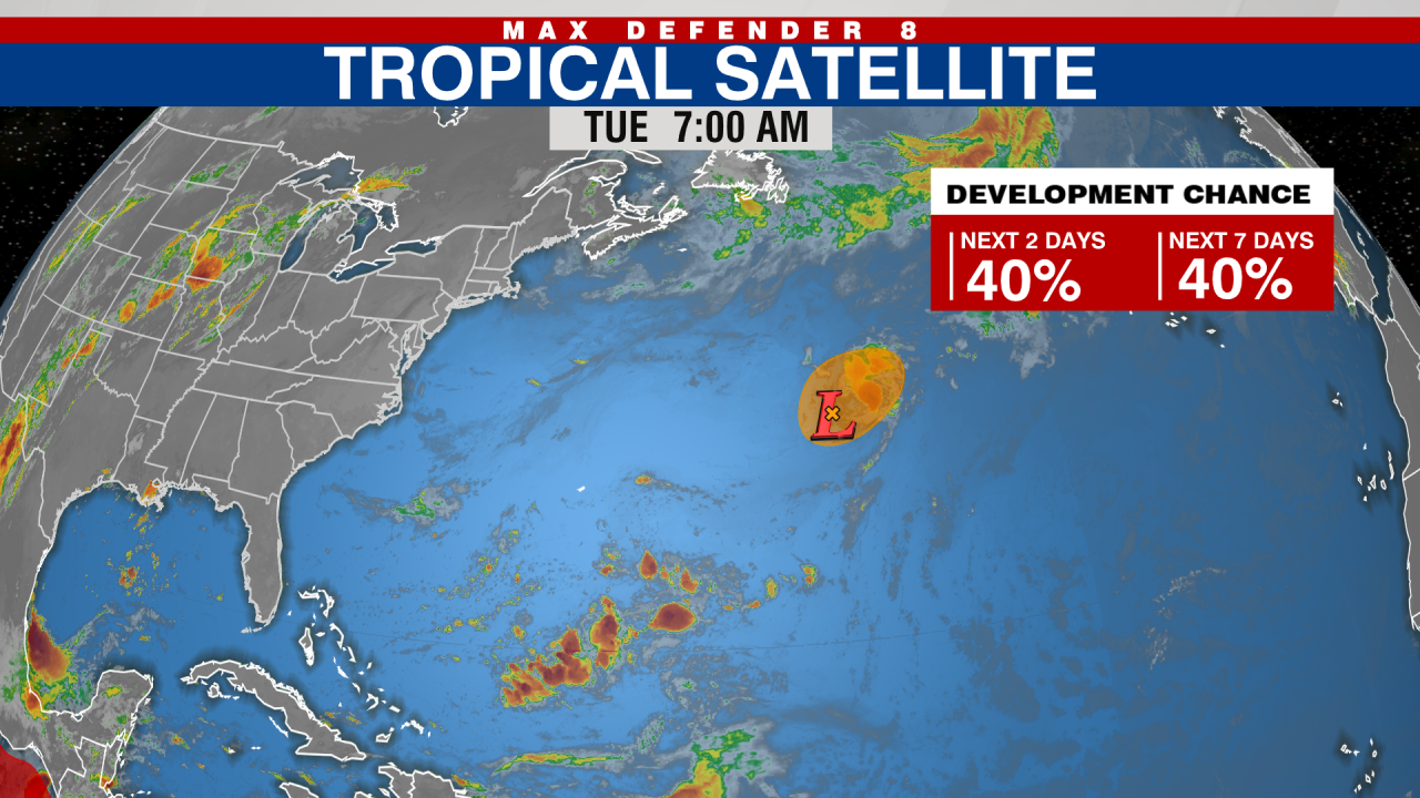
Tropical Storm Andrea now expected to form in central Atlantic on Tuesday
Tropical Storm Andrea is now expected to form in the central Atlantic Ocean on Tuesday, though it is expected to be “short-lived” A broad area of showers and thunderstorms associated with an area of low pressure some 900 miles east-northeast of Bermuda is being tracked by the NHC as Invest 90L.
A broad area of showers and thunderstorms associated with an area of low pressure some 900 miles east-northeast of Bermuda is being tracked by the NHC as Invest 90L.
An invest is a naming convention used by the NHC to identify areas it is investigating for possible development into a tropical depression or tropical storm within the next seven days.
According to the NHC, thunderstorms within Invest 90L have become better organized as of Tuesday morning.
WHAT IS AN INVEST DURING HURRICANE SEASON?
“This system will likely become a short-lived tropical storm later today before more hostile environmental conditions end its opportunity for development by this evening,” the NHC wrote in its latest outlook.
The outlook for Invest 90L in the central subtropical Atlantic.
(FOX Weather)
The NHC currently gives Invest 90L a 70% chance of development.
The first three weeks of the Atlantic hurricane season were void of any tropical threats.
Regardless of development, this system will not threaten any land areas as it moves northeastward at about 15-20 mph across the open waters of the central Atlantic.
HOW TO WATCH FOX WEATHER
In an average season, the first named storm in the Atlantic forms around June 20.
The Atlantic hurricane season runs from June 1 to Nov. 30.
AccuWeather says Florida could see Tropical Storm Sara next week; NHC tracking disturbance
A tropical wave dumping torrential rain in the Caribbean is likely to develop into a tropical depression within the next two to three days. The wave is on course to approach the same region of warm water that produced hurricanes Rafael, Milton and Helene. What happens next depends on the position of a dome of high pressure along the southern Atlantic coast. If the high pressure stays where it is, it will likely steer the storm into Central America or southeastern Mexico later this weekend to next week. The next named storm of the Atlantic Hurricane season would be Sara. The Atlantic hurricane season runs from June 1 through Nov. 30. The northern Gulf Coast, including Florida, can expect high surf and dangerous rip currents. The Gulf of Mexico may meander around a cold front moving over the U.S. Wednesday and Thursday, bringing heavy rain to Mississippi, Louisiana, Alabama, Tenneessee, and the tip of the Florida Panhandle.
AccuWeather forecasters are predicting it will be Tropical Storm Sara, and saying it could threaten Florida as a hurricane next week.
“We’ll likely be dealing with a hurricane as we head into this weekend. There is increasing confidence that a tropical storm will develop in the central to western Caribbean later this week,” AccuWeather Lead Hurricane Expert Alex DaSilva said in an email release. “We could be dealing with a storm that rapidly intensifies into a major hurricane in these very conducive conditions. The atmosphere is primed for development.”
The wave is on course to approach the same region of warm water that produced hurricanes Rafael, Milton and Helene. What happens next depends on the position of a dome of high pressure along the southern Atlantic coast.
If the high pressure stays where it is, it will likely steer the storm into Central America or southeastern Mexico later this weekend to next week, AccuWeather said.
If the dome of high pressure moves away or weakens, it could allow steering breezes to guide the storm toward the Florida Keys and South Florida or along the Gulf coast.
Meanwhile, remnants of Rafael may meander around the Gulf of Mexico and get swept up into a cold front moving over the U.S. Wednesday and Thursday, bringing heavy rain to Mississippi, Louisiana, Alabama, Tenneessee, and the tip of the Florida Panhandle. The northern Gulf Coast, including Florida, can expect high surf and dangerous rip currents.
➤ Weather alerts via text: Sign up to get updates about current storms and weather events by location
The next named storm of the Atlantic Hurricane season would be Sara.
Here’s the latest update from the NHC as of 1 p.m. EST Tuesday, Nov. 12:
National Hurricane Center map: What else is out there and how likely are they to strengthen?
Systems currently being monitored by the National Hurricane Center include:
Central and Western Caribbean Sea: Disorganized showers and thunderstorms over the central Caribbean Sea are associated with a broad area of low pressure. Environmental conditions appear conducive for development, and a tropical depression is likely to form within the next two to three days while the system moves slowly westward into the western Caribbean Sea.
Afterward, further development is likely while the disturbance meanders over the western Caribbean Sea through the weekend.
The system is forecast to begin moving slowly northwestward by early next week. Interests across the western and northwestern Caribbean Sea should monitor the progress of this system.
Formation chance through 48 hours: medium, 60 percent.
Formation chance through seven days: high, 90 percent.
What do the colored areas on the NOAA map mean?
The hatched areas on a tropical outlook map indicate “areas where a tropical cyclone — which could be a tropical depression, tropical storm or hurricane — could develop,” said National Hurricane Center Deputy Director Jamie Rhome.
The colors make it visibly clear how likely a system could develop with yellow being low, orange medium and red high.
The National Hurricane Center generally doesn’t issue tropical advisories until a there is a named storm, but there is an exception.
“If a system is near land and there is potential for development, the National Hurricane Center won’t wait before it issues advisories, even if the system hasn’t become an actual storm. This gives residents time to prepare,” Rhome said.
Weather watches and warnings issued in Florida
When does hurricane season end?
The Atlantic hurricane season runs from June 1 through Nov. 30.
The Atlantic basin includes the northern Atlantic Ocean, Caribbean Sea and Gulf of Mexico.
Interactive map: Hurricanes, tropical storms that have passed near your city
Excessive rainfall forecast
Stay informed. Get weather alerts via text
What’s next?
We will continue to update our tropical weather coverage daily. Download your local site’s app to ensure you’re always connected to the news. And look for our special subscription offers here.
(This story was updated with new information.)