NASA Spacecraft Orbiting Mars Captures Image of Giant Ancient Volcano Just Before Dawn
How did your country report this? Share your view in the comments.
Diverging Reports Breakdown
Arsia Mons pokes through the clouds
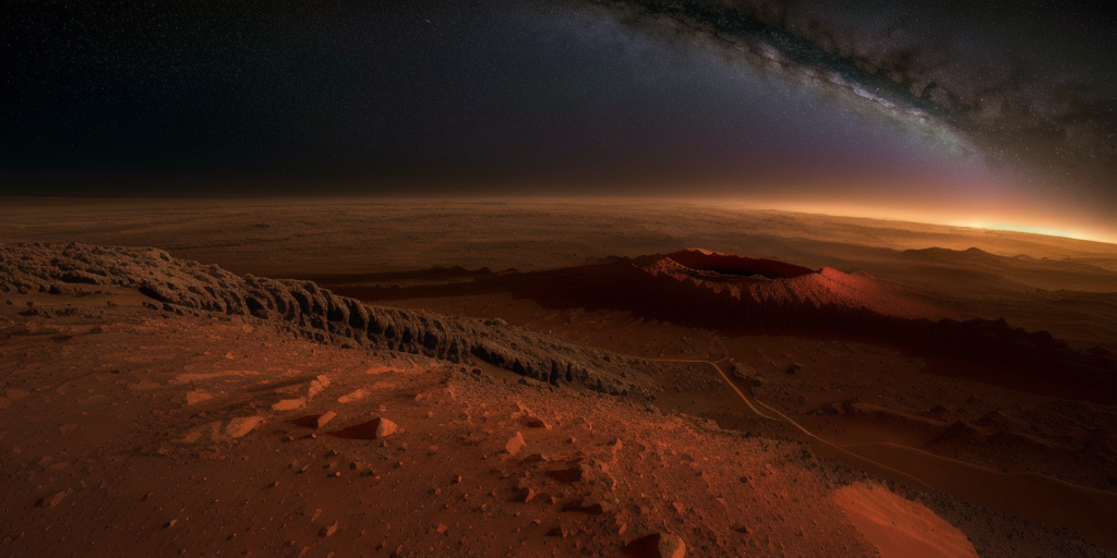
NASA’s longest-running Martian orbiter, Mars Odyssey, has captured a dramatic, ethereal image of a 20km-tall volcano towering above a sea of clouds on Mars. Arsia Mons is the southernmost of three volcanoes that make up the Red Planet’s Tharsis Montes mountain range. This is the first time a volcano on Mars has been photographed from the planet’s horizon, giving us a perspective similar to images of Earth captured from the International Space Station. The scene isn’t just volcanic drama; it’s also a key piece of data for scientists wanting to learn more about Mars’s atmosphere. It’s also a scientific treasure trove of what Mars explorers might see with their own eyes one day, as well as a glimpse into the future of space exploration on the planet. The Mars Odyssey orbiter launched in 2001 and is still going strong. In 2023, it began rotating 90° mid-orbit to capture high-altitude, horizon-facing images with its THEMIS camera.
The star of the show is Arsia Mons, the southernmost of three volcanoes that make up the Red Planet’s Tharsis Montes mountain range.
This is the first time a volcano on Mars has been photographed from the planet’s horizon, giving us a perspective similar to images of Earth captured from the International Space Station.
Might we one day have a space station orbiting Mars? If so, this is what its inhabitants might see.
Arsia Mons, an ancient volcano on Mars captured before dawn on 2 May 2025 by NASA’s 2001 Mars Odyssey orbiter. Credit: NASA/JPL-Caltech/ASU
Ice clouds on Mars
The scene isn’t just volcanic drama; it’s also a key piece of data for scientists.
In the image, Mars Odyssey has captured water ice clouds swirling around Arsia Mons in the early morning light.
These clouds form as cold Martian air is forced up the volcano’s slopes, cooling rapidly and condensing into visible vapour.
The phenomenon intensifies during Mars’ aphelion, which is the point in its orbit when it’s furthest from the Sun.
When this happens, a spectacular belt of clouds known as the ‘aphelion cloud belt’ stretches across the Martian equator.
In Odyssey’s image, Arsia Mons is seen poking majestically through that belt.
Arsia Mons is the southernmost of the three volcanoes that make up Tharsis Montes, shown in the center of this cropped topographic map of Mars. Olympus Mons, the solar system’s largest volcano, is at upper left. The western end of Valles Marineris begins cutting its wide swath across the planet at lower right. Credit: NASA/JPL-Caltech
Arsia Mons, the mega Martian mountain
Arsia Mons towers 20km (12 miles) above the surface of Mars, which is more than twice as tall as Mauna Loa, Earth’s tallest volcano when measured from its base on the seafloor.
The Tharsis region, home to Arsia Mons and its volcanic siblings, includes some of the largest volcanic structures in the entire Solar System.
Notably Olympus Mons, the largest and tallest volcano in the Solar System.
Arsia Mons is the cloudiest of the three giants that make up Tharsis Montes, making it a prime target for planetary scientists wanting to learn more about Mars’s atmosphere.
Artist’s impression of the Mars Odyssey Orbiter. Credit: NASA/JPL-Caltech
Two decades in orbit
Mars Odysses launched in 2001 and is still going strong.
In 2023, it began rotating 90° mid-orbit to capture high-altitude, horizon-facing images with its THEMIS (Thermal Emission Imaging System) camera.
This enables planetary scientists to observe seasonal changes in Mars’s atmosphere, which is key for understanding weather patterns and planning future missions.
If we’re ever to set human feet on Mars, data like this is invaluable in terms of keeping crew safe.
Video showing the launch of the Mars Odyssey orbiter
“We’re seeing some really significant seasonal differences,” says NASA planetary scientist Michael D. Smith.
“It’s giving us new clues to how Mars’ atmosphere evolves over time.”
What’s more, the THEMIS camera can peer beneath the surface using infrared light to locate buried water ice.
Water would be a valuable resource for any crewed base on Mars, as it can be used as drinking water, but could also potentially provide oxygen or even be used as rocket propellant.
So while this image of Arsia Mons feels like a postcard from another world, it’s also a scientific treasure trove, as well as a glimpse into the future of what Mars explorers might see with their own eyes one day.
“We picked Arsia Mons hoping we would see the summit poke above the early morning clouds,” says Jonathon Hill of Arizona State University in Tempe, operations lead for Odyssey’s THEMIS instrument.
“And it didn’t disappoint.”
Mars Orbiter Captures Rare View of Ancient Volcano Poking Above the Clouds
Odyssey captured the image on May 2, just before dawn. In it, Arsia Mons stands 12 miles (20 kilometers) high and measures 70 miles (450 km) in diameter. For comparison, Earth’s tallest volcano, Mauna Loa, stands 6 miles (9 km) above the seafloor and measures 75 miles (121 km) In the image, the volcano peeps over a thick layer of clouds, showing the Red Planet’s horizon at an angle in space that captures the planet’s horizon.
Floating in orbit above Mars, NASA’s 2001 Mars Odyssey orbiter captured a panorama of the Red Planet’s biggest volcanoes, Arsia Mons, peeking over a sea of clouds. The picturesque moment offers an exceptionally rare view of a Martian volcano, showing the landform at an angle in space that captures the planet’s horizon.
“We picked Arsia Mons hoping we would see the summit poke above the early morning clouds. And it didn’t disappoint,” Jonathon Hill, the operations lead for Odyssey’s camera and a mission planner at Arizona State University’s Mars Space Flight Facility, called the Thermal Emission Imaging System, or THEMIS, said in a statement. THEMIS can view Mars in both visible and infrared light.
Launched in 2001, Odyssey has been circling around Mars for over two decades, studying the Martian surface. But in 2023, the orbiter began taking breathtaking panoramic views of the Martian horizon. Because THEMIS can’t pivot to get these stunning views, the orbiter flips on its side, rotating a full 90 degrees. That way, it captured Mars’ “limb,” the edge of the planet’s horizon. This is THEMIS’ fourth limb observation since 2023.
Odyssey captured the image on May 2, just before dawn. In it, Arsia Mons stands 12 miles (20 kilometers) high and measures 70 miles (450 km) in diameter. For comparison, Earth’s tallest volcano, Mauna Loa, stands 6 miles (9 km) above the seafloor and measures 75 miles (121 km) in diameter.
Arsia Mons is also one of Mars’ cloudiest volcanoes and the southernmost of the three Tharsis volcanoes that form Tharsis Montes, or Tharsis Mountains. These mountains are often surrounded by water ice clouds, particularly early in the morning. The clouds form when air expands as it blows up the sides of the mountain and then rapidly cools.
This view also allows scientists to study Martian weather and phenomena like dust clouds and how they change over the course of the seasons. Odyssey might be able to capture a few more of these panoramas before its eventual retirement, likely at the end of this year.
NASA Captures Mars Volcano Twice The Height Of Earth’s Tallest Peaks
NASA’s 2001 Mars Odyssey orbiter has captured a stunning picture of a 20-kilometer-high volcano, peeping through the clouds on the Red Planet. Arsia Mons stands 20 kilometers high, surpassing Earth’s Mauna Loa volcano by double its height. At 120 kilometres wide, the summit caldera is also larger than many volcanoes on Earth. The panorama image taken on May 2, using the Thermal Emission Imaging System (THEMIS), shows the planet’s massive volcano for the first time. The angle of the camera allows scientists to see dust and water ice cloud layers, enabling them to observe changes over the course of seasons.
NASA’s 2001 Mars Odyssey orbiter has captured a stunning picture of a 20-kilometer-high volcano, peeping through the clouds on the Red Planet. The image captured from the upper atmosphere at dawn, shows a green haze with Arsia Mons standing roughly twice as tall as Earth’s largest volcano, Mauna Loa, located in Hawaii, which rises nine kilometers above the seafloor. At 120 kilometres wide, the Arsia Mons summit caldera is also larger than many volcanoes on Earth.
The panorama image taken on May 2, using the Thermal Emission Imaging System (THEMIS), shows the planet’s massive volcano for the first time. Arsia Mons is the southernmost of the Tharsis volcanoes and cloudiest of the three.
“We picked Arsia Mons hoping we would see the summit poke above the early morning clouds. And it didn’t disappoint,” said Jonathon Hill of Arizona State University in Tempe, operations lead for THEMIS.
Researchers said the clouds are especially thick over Arsia Mons when the Red Planet is farthest from the sun, a period called aphelion.
Advertisement
“Understanding Mars’ clouds is particularly important for understanding Martian weather and how phenomena like dust storms occur,” NASA stated.
Something big is peeking through Martian clouds. 🌋
The Odyssey orbiter captured a stunning view of Arsia Mons, a volcano that dwarfs the tallest ones here on Earth. This perspective helps scientists study how dust and ice clouds change over the seasons. https://t.co/p1BIiSQokr pic.twitter.com/SxvGJE6itw — NASA JPL (@NASAJPL) June 6, 2025
Also Read | US Researcher Proposes Detonating Massive Nuclear Bomb Under Ocean To Save Earth
The Odyssey orbiter was launched in 2001 and is regarded as the longest-running mission orbiting another planet. To click the picture, the orbiter rotates 90 degrees while in orbit so that its camera, built to study the Martian surface, can capture it cleanly.
Advertisement
The angle of the camera allows scientists to see dust and water ice cloud layers, enabling them to observe changes over the course of seasons.
“We’re seeing some really significant seasonal differences in these horizon images,” said planetary scientist Michael D. Smith of NASA’s Goddard Space Flight Center in Greenbelt, Maryland. “It’s giving us new clues to how Mars’ atmosphere evolves over time.”
Advertisement
NASA Spots Strange Towering Shape Breaking Through Mars’ Atmosphere
A new image from NASA’s Mars Odyssey orbiter reveals an extraordinary sight: a massive formation breaking through Mars’ early morning cloud cover. Taken just before dawn on May 2, 2025, the photograph offers an unprecedented view of the Martian horizon. It is the first time a feature of this scale has been seen from orbit rising above the clouds, offering a perspective normally associated with Earth-based spaceflight. The image is part of an ongoing effort to study Mars’ upper atmosphere across different seasons. By monitoring these changes, researchers can better understand long-term climate behavior and its impact on surface conditions on the Red Planet. The images were captured by rotating the spacecraft 90 degrees in orbit, allowing its camera to observe the edge of the Mars atmosphere instead of the ground below. The dynamic behavior of the clouds hints at a planet in constant atmospheric motion, which could help scientists better understand the planet’s climate.
A Towering Shape Emerges From the Martian Haze
In the image, a single massive peak emerges from a blanket of clouds that hover low over the Martian surface. The formation, located in Mars’ Tharsis region, appears to pierce the upper atmosphere like a sentinel at the edge of the world. The clouds surrounding it are composed primarily of water ice, which forms in the cooler temperatures of early morning. The visual contrast—between the pale, luminous clouds and the dark structure rising above them—creates a scene that feels alien and almost otherworldly. Jonathon Hill, operations lead for Odyssey’s Thermal Emission Imaging System (THEMIS), commented, “We picked this location hoping we would see the summit poke above the early morning clouds. And it didn’t disappoint.”
Arsia Mons is the southernmost of the three volcanoes that make up Tharsis Montes, shown in the center of this cropped topographic map of Mars. Olympus Mons, the solar system’s largest volcano, is at upper left. The western end of Valles Marineris begins cutting its wide swath across the planet at lower right.
Credit: NASA/JPL-Caltech
A Seasonal Shift Unlocks New Atmospheric Clues
The image is part of an ongoing effort to study Mars’ upper atmosphere across different seasons. Since 2023, Odyssey has been capturing high-altitude views of the Martian horizon, offering insight into cloud dynamics, dust patterns, and the layering of the atmosphere itself. These observations are helping scientists track how the Red Planet’s weather evolves over time. “We’re seeing some really significant seasonal differences in these horizon images,” said Michael D. Smith, planetary scientist at NASA’s Goddard Space Flight Center. “It’s giving us new clues to how Mars’ atmosphere evolves over time.” By monitoring these changes, researchers can better understand long-term climate behavior and its impact on surface conditions.
Arsia Mons, an ancient Martian volcano, was captured before dawn on May 2, 2025, by NASA’s 2001 Mars Odyssey orbiter while the spacecraft was studying the Red Planet’s atmosphere, which appears here as a greenish haze. come
Credit: NASA/JPL-Caltech/ASU
Cloud Formations Reveal a Planet in Motion
The rising structure is frequently surrounded by dense morning clouds—particularly during Mars’ aphelion, the point in its orbit when it is farthest from the Sun. During this period, a broad band of clouds stretches around the planet’s equator, known as the aphelion cloud belt. These clouds form as moist air ascends over high terrain, cools rapidly, and condenses. The newly released image captures this process in dramatic detail, with the formation pushing through the uppermost layer of atmosphere like an island in a sea of fog. Though the feature is stationary, the dynamic behavior of the clouds hints at a planet in constant atmospheric motion.
A New Role for a Veteran Spacecraft
Odyssey’s THEMIS instrument, originally designed for surface imaging, has proven increasingly valuable for atmospheric studies. It can detect visible and infrared light, allowing it to analyze temperature variations, identify subsurface water ice, and even study Mars’ two moons, Phobos and Deimos. These capabilities have enabled the long-running spacecraft—now the oldest operating mission at Mars—to adapt to new scientific goals. By observing the horizon instead of the surface, THEMIS is contributing to a deeper understanding of the Martian climate system, and capturing views that were once considered out of reach.