Tornado warning issued in portion of central NC as Chantal moves inland
How did your country report this? Share your view in the comments.
Diverging Reports Breakdown
Tropical Storm Chantal makes landfall in South Carolina
Tropical Storm Chantal moved onshore in South Carolina early Sunday morning and continued to dump heavy rain on parts of the Southeast while weakening to a depression. The hurricane center said flash flooding remained a threat for areas in northeastern South Carolina and eastern North Carolina through at least Monday. There are no other potential tropical trouble spots as of Sunday in the Atlantic Basin, which includes the Gulf and Caribbean. The Atlantic hurricane season is expected to be a busy one, with an above-average number of storms expected before the end of the season on Nov. 30.
Tropical Storm Chantal moved onshore in South Carolina early Sunday morning and continued to dump heavy rain on parts of the Southeast while weakening to a depression.
The National Hurricane Center said Chantal, the third named storm of 2025 in the Atlantic, moved onshore around 3 a.m. Sunday near Litchfield, S.C. Forecasters added that the storm had been losing its structure and its exact center was tough to pin down.
However, the storm peaked with 60 mph winds before moving onshore overnight, according to the hurricane center.
Chantal weakened to a tropical depression later on Sunday morning and continued to move inland. The hurricane center said flash flooding remained a threat for areas in northeastern South Carolina and eastern North Carolina through at least Monday.
As of 10 a.m. CDT Sunday, the center of Tropical Depression Chantal was located about 80 miles west of Wilmington, N.C., and was moving north at 9 mph, according to the hurricane center.
Tropical Depression Chantal was expected to continue moving inland on Sunday while weakening. NHC
Chantal’s sustained winds decreased to 35 mph.
The hurricane center said all tropical storm warnings and watches had been dropped as of late Sunday morning.
The hurricane center expects what’s left of Chantal to move further inland over South Carolina and then North Carolina through the day on Sunday while weakening.
Chantal is expected to weaken to a trough of low pressure by Monday.
There will continue to be a threat for flash flooding. Chantal could bring 2 to 4 inches of rain to areas in northeastern South Carolina today and North Carolina through Monday.
There will also continue to be the risk of deadly rip currents along the coast far from the storm. Rip currents will be possible from northeastern Florida northward into the mid-Atlantic region over the next day or two, forecasters said.
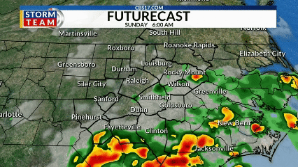
If that wasn’t enough, a tornado or two will be possible Sunday across portions of eastern North Carolina and extreme northeastern South Carolina.
There are no other potential tropical trouble spots as of Sunday in the Atlantic Basin, which includes the Gulf and Caribbean.
The Atlantic hurricane season is expected to be a busy one, however, with an above-average number of storms expected before the end of the season on Nov. 30.
Tropical Storm Chantal brings heavy rains as it moves across northeastern South Carolina
Tropical Storm Chantal is forecast to bring heavy rains as it moves inland across northeastern South Carolina. The storm was about 70 miles (112 kilometers) east of Charleston, South Carolina, early Sunday. Its maximum sustained winds were clocked at 50 mph (80 kph)
MIAMI – Tropical Storm Chantal is forecast to bring heavy rains as it moves inland across northeastern South Carolina on Sunday.
Leer en español
Recommended Videos
Tropical storm warnings were issued for portions of the two Carolinas, the National Hurricane Center in Miami said.
The storm was about 70 miles (112 kilometers) east of Charleston, South Carolina, early Sunday, and 85 miles (136 kilometers) southwest of Wilmington, North Carolina. Its maximum sustained winds were clocked at 50 mph (80 kph), and it was moving north at 8 mph (13 kph).
Rain bands from Chantal were moving onshore, the hurricane center said, with flash floods an increasing concern.
Heavy rain was forecast for parts of North Carolina through Monday, with total rainfall of 2 to 4 inches (5 to 10 centimeters) and local amounts up to 6 inches (15 centimeters) that could lead to flash flooding.
South Carolina’s Emergency Management division had warned residents earlier of the possibility of isolated tornadoes along the coast and of minor coastal flooding.
It also warned drivers not to venture on water-covered roads or around road-closure signs where flooding occurred.
Tropical Storm Chantal strikes Carolina coast
Tropical Storm Chantal is now just inland in far eastern South Carolina. The storm is forecast to drop 2-4 inches of rain with some areas getting up to 6 inches. It was the first storm of the 2025 Atlantic hurricane season to strike the United States. The National Oceanic and Atmospheric Administration forecasts 13 to 19 named storms this year. Three to five of those would grow into major hurricanes of Category 3 strength or higher.
As of the National Hurricane Center’s 11 a.m. advisory, the storm had diminished into a tropical depression with maximum sustained winds of 35 mph as it moved into eastern North Carolina. It was located about 20 miles southwest of Lumberton and 80 miles west of Wilmington, N.C. moving north at 9 mph.
“A turn toward the northeast is expected this evening and that motion should continue into Monday. On the forecast track, the center of Chantal is expected to move over eastern North Carolina through tonight,” forecasters said. “Additional weakening is expected during the next 24 hours, and the system is expected to degenerate into a trough of low pressure on Monday.”
5am EDT Sunday July 6th Key Messages for Tropical Storm #Chantal: Chantal is now just inland in far eastern South Carolina. TS conditions expected in the warning area coast this morning, but heavy rainfall will persist over SC today & NC through Monday.https://t.co/cXWFasn84V pic.twitter.com/NBM91ETQJM — National Hurricane Center (@NHC_Atlantic) July 6, 2025
The storm is forecast to drop 2-4 inches of rain with some areas getting up to 6 inches over portions northeastern South Carolina today and across portions of North Carolina through Monday, bringing with it a threat for flooding.
“An isolated tornado or two is possible today over parts of eastern North Carolina,” the NHC warned.
Rough surf and rip currents are a threat from northeastern Florida to the mid-Atlantic into Monday.
Chantal was the first storm of the 2025 Atlantic hurricane season to strike the United States.
The National Oceanic and Atmospheric Administration forecasts 13 to 19 named storms this year, of which 6-10 will become hurricanes. Three to five of those would grow into major hurricanes of Category 3 strength or higher.
Hurricane season runs June 1-Nov. 30.