Tropical Chantal heading toward the Carolinas, some heavy rain likely in parts of the Piedmont Triad, July 5 Update
How did your country report this? Share your view in the comments.
Diverging Reports Breakdown
Tropical Storm Chantal closes in on Carolinas with increasing winds
Tropical Storm Chantal has sustained 50 mph winds with higher gusts. A tropical storm warning is in effect from South Santee River, S.C., to Surf City, N.C. The storm is expected to produce heavy rain across portions of the Carolinas through Monday. Rain and thunderstorms are likely in South Florida into next week, according to the National Weather Service forecast.. Colorado State University’s hurricane forecast for 2025 estimates 17 named storms, with nine of them.
The storm was located about 65 miles east of Charleston and 120 miles south-southwest of Wilmington, N.C., and saw its speed tick upward to 8 mph, according to the 11 p.m. advisory from the National Hurricane Service. Rain bands began pelting the coastal areas Saturday evening.
A tropical storm warning was in effect from South Santee River, S.C., to Surf City, N.C.
“A motion toward the north-northwest is expected to begin overnight, followed by a turn to the northeast by Sunday night,” the hurricane center’s advisory said. “On the forecast track, the center of Chantal is expected to move across the coast of South Carolina overnight or early Sunday morning.
“Rapid weakening” is expected after the storm makes landfall.
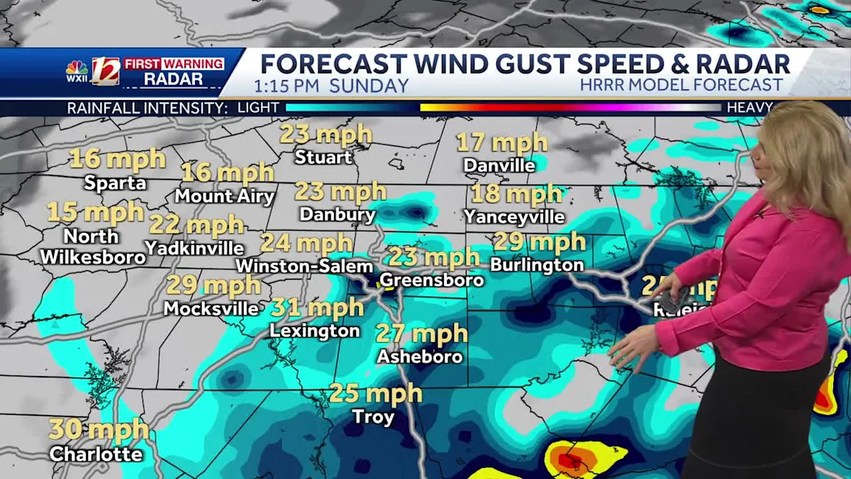
Chantal, once a slow-moving storm traveling at 1 mph that formed offshore earlier in the day, was expected to produce heavy rain across portions of the Carolinas through Monday totaling 2 to 4 inches with local amounts up to 6 inches.
There was an “elevated risk for flash flooding,” the advisory said.
Forecasters said storm surge and the tide would cause flooding in normally dry areas as Chantal moved inland.
They also warned of isolated tornadoes Saturday night into Sunday along the South Carolina coast and “much of North Carolina.”
“Life-threatening surf and rip currents” in coastal areas also are expected, the advisory added, “from northeastern Florida to the Mid-Atlantic states during the next couple of days.”
The center advised all interests along the southeast coast of the United States to monitor the storm’s progress.
Rain and thunderstorms are likely in South Florida into next week, according to the National Weather Service forecast.
Colorado State University’s hurricane forecast for 2025 estimates 17 named storms, with nine of them becoming hurricanes.
Hurricane season runs through Nov. 30.
Tropical Storm Chantal moves toward South Carolina for Sunday landfall
The tropical storm poses no direct threat to the Gulf Coast of South Florida. The main impacts are expected to be heavy rainfall and potential flooding, with occasional high wind gusts. The forecast cone for the system shows it moving generally northward through early Sunday off the coast of Georgia. By late Sunday, this system is forecast to be over land and weakening as it approaches North Carolina. On average, the third named system in the Atlantic falls on August 3rd, but this is certainly not unusual activity. Count on Gulf Coast News to keep you updated as we continue to track this system. Check out the interactive Gulf Coast Live RadarWatch your Gulf Coast Weather forecasts on TV or onlineHere’s where to find our latest weather forecast video.
Tropical Storm Chantal in the Atlantic is set to make landfall on Sunday morning in South Carolina.As of 11 p.m. Saturday, the storm’s center is located 65 miles southeast of Charleston, South Carolina, with 50 mph sustained winds. The system’s forward motion is toward the north at 8 mph. The main impacts are expected to be heavy rainfall and potential flooding, with occasional high wind gusts. The forecast cone for the system shows it moving generally northward through early Sunday off the coast of Georgia.Since the system is moving away from our local area, it poses no direct threat to our community along the Gulf Coast.By late Sunday, this system is forecast to be over land and weakening as it approaches North Carolina. On average, the third named system in the Atlantic falls on August 3rd, but this is certainly not unusual activity. Count on Gulf Coast News to keep you updated as we continue to track this system. Live Interactive RadarCheck out the interactive Gulf Coast Live RadarWatch your Gulf Coast Weather forecasts on TV or onlineHere’s where to find our latest weather forecast videoYou can also watch newscasts live or on-demand hereOr download the Gulf Coast News app to stream on your phone or tabletFollow the Gulf Coast Storm Team on social mediaChief Meteorologist Allyson Rae on Facebook and XMeteorologist Jim Dickey on Facebook and XMeteorologist Jason Dunning on Facebook and XMeteorologist Rob Duns on Facebook and XMeteorologist Lauren Hope on Facebook and XMeteorologist Raphael Tavernier on Facebook and XDOWNLOAD the free Gulf Coast News app for your latest breaking news and weather alerts.
Tropical Storm Chantal in the Atlantic is set to make landfall on Sunday morning in South Carolina.
As of 11 p.m. Saturday, the storm’s center is located 65 miles southeast of Charleston, South Carolina, with 50 mph sustained winds. The system’s forward motion is toward the north at 8 mph.
Advertisement
The main impacts are expected to be heavy rainfall and potential flooding, with occasional high wind gusts.
The forecast cone for the system shows it moving generally northward through early Sunday off the coast of Georgia.
Since the system is moving away from our local area, it poses no direct threat to our community along the Gulf Coast.
Gulf Coast News
By late Sunday, this system is forecast to be over land and weakening as it approaches North Carolina.
Gulf Coast News Tropical watches and warnings.
On average, the third named system in the Atlantic falls on August 3rd, but this is certainly not unusual activity.
Count on Gulf Coast News to keep you updated as we continue to track this system.
Live Interactive Radar
Check out the interactive Gulf Coast Live Radar
Watch your Gulf Coast Weather forecasts on TV or online
Follow the Gulf Coast Storm Team on social media
Chief Meteorologist Allyson Rae on Facebook and X
and Meteorologist Jim Dickey on Facebook and X
and Meteorologist Jason Dunning on Facebook and X
and Meteorologist Rob Duns on Facebook and X
and Meteorologist Lauren Hope on Facebook and X
and Meteorologist Raphael Tavernier on Facebook and X
Energy crews prepare for impact of Tropical Storm Chantal
Energy crews prepare for impact of Tropical Storm Chantal. Duke Energy crews are preparing for all possibilities. “You’re going to see some scattered outages,” says Jeff Brooks with Duke Energy. “We want to get our crews home at the end of the day, even though they’re out helping you during some tough conditions,” he says. “Please use extreme caution if you see a utility crew working along the side of the road, move over, slow down, and give them the space to do their work safely,” Brooks says. The high winds combined with rain can lead to downed lines.
As Tropical Storm Chantal makes its way toward North Carolina, Duke Energy crews are preparing for all possibilities.
As Tropical Storm Chantal makes its way toward North Carolina, Duke Energy crews are preparing for all possibilities.
As Tropical Storm Chantal makes its way toward North Carolina, Duke Energy crews are preparing for all possibilities.
As Tropical Storm Chantal makes its way toward North Carolina, Duke Energy crews are preparing for all possibilities.
RALEIGH, N.C. (WTVD) — As Tropical Storm Chantal makes its way toward North Carolina, Duke Energy crews are preparing for all possibilities.
“You’re going to see some scattered outages. You may see some heavier pockets. You’re probably not going to see, most likely, the widespread outages we see with, you know, something like Helene or a bigger storm, but that doesn’t mean you don’t take it seriously,” said Jeff Brooks with Duke Energy.
Duke Energy said even if you’re not in the direct path, which might be closer to the coast, they’re also watching in central North Carolina, just in case.
The high winds combined with rain can lead to downed lines.
ALSO SEE First Alert Day: Rain expected over weekend on NC Coast, Triangle due to Tropical Storm Chantal
“You are going to have some heavy rain. So that could bring down some trees here. And there, if it brings down a power line, you always need to assume that power one has electricity on it, stay away from it, keep your pets and your family away from it, and give us a cal,l and we’ll get out there and repair it,” Brooks said.
Duke Energy said its crews are ready to respond, and said it’s important to stay off the roads if possible to be safe.
“And so if you’re out driving, please use extreme caution if you see a utility crew working along the side of the road, move over, slow down, and give them the space to do their work safely. Safety is our first priority, and we want to get our crews home at the end of the day, even though they’re out helping you during some tough conditions,” he said.
Some tips to prepare ahead of the storm:
Prepare an emergency kit
Stay away from windows and doors, seek shelter in interior rooms
Disconnect nonessential electrical equipment to avoid overload when power comes back on
ALSO SEE If you lose power: Here’s how to report and check power outages in your area
RELATED Keep your phone, other electronic devices charged during a power outage, here’s how to do that
UPDATE: Tropical cyclone statement issued for Eastern North Carolina until Sunday morning
Tropical Storm Chantal will approach the South Carolina coast tonight, strengthening slightly before landfall. The main impact for the Carolinas will be locally heavy rainfall with potential for isolated flooding tonight through Sunday. Strong rip currents and dangerous surf are also expected. Hazardous surf conditions will continue through early next week. Life-threatening rip currents possible at all area beaches Saturday and Sunday. High surf forecasted for the beaches of northeast SC and Brunswick county through Sunday, with breaking wave heights of six feet likely and minor beach erosion possible. Protect against locally hazardous surge having possible limited impacts along the coastline of southeast North Carolina and northeast South Carolina. A few small craft may break away from moorings if not properly secured. Tornadoes can cause damage to trees, vehicles, boats, buildings and poorly constructed structures. Failure to adequately shelter may result in serious injury or loss of life. Always heed the advice of local officials and comply with any orders that are issued. Remember, Emergency Services may not be able to respond immediately to storm conditions.
The creation of this content included the use of AI based on templates created, reviewed and edited by journalists in the newsroom. Read more on our AI policy here.
At 11:12 p.m. on Saturday, the NWS Wilmington NC released an updated tropical cyclone statement in effect until Sunday at 7:15 a.m. The statement is for Inland Pender, Coastal Pender, Inland New Hanover, Coastal New Hanover, Inland Brunswick and Coastal Brunswick.
The following information is provided by the NWS:
This product covers southeast North Carolina and northeast South Carolina CURRENT WATCHES AND WARNINGS: – A Tropical Storm Warning is in effect for Central Horry, Coastal Brunswick, Coastal Georgetown, Coastal Horry, Coastal New Hanover, Coastal Pender, and Inland Georgetown STORM INFORMATION: – About 120 miles south-southwest of Wilmington NC or about 70 miles south of Myrtle Beach SC – 32.7N 78.8W – Storm Intensity 50 mph – Movement North or 350 degrees at 8 mph SITUATION OVERVIEW —————— Tropical Storm Chantal will approach the South Carolina coast tonight, strengthening slightly before landfall. The main impact for the Carolinas will be locally heavy rainfall with potential for isolated flooding tonight through Sunday. Strong rip currents and dangerous surf are also expected. Hazardous surf conditions will continue through early next week. POTENTIAL IMPACTS —————– * FLOODING RAIN: Protect against dangerous rainfall flooding having possible significant impacts across southeast North Carolina and coastal areas of northeast South Carolina. Potential impacts include: – Moderate flooding from rainfall may prompt some evacuations and rescues. – Rivers and streams may rise and overspill their banks in a few places, especially in the typical prone locations. Small creeks and ditches may overflow. – Flood waters may enter some structures. Underpasses, low-lying spots along roadways, and poor drainage areas may become submerged by rising water. Some secondary streets and parking lots may flood as storm drains and retention ponds overflow. – Driving conditions will become hazardous, and some road closures can be expected. Protect against locally hazardous rainfall flooding having possible limited impacts across northeast South Carolina and the Pee Dee region. OTHER COASTAL HAZARDS: Life-threatening rip currents possible at all area beaches Saturday and Sunday. High surf forecasted for the beaches of northeast SC and Brunswick county through Sunday, with breaking wave heights of six feet likely and minor beach erosion possible. SURGE: Protect against locally hazardous surge having possible limited impacts along the coastline of southeast North Carolina and northeast South Carolina. Potential impacts in this area include: – Localized inundation and minor overwash are possible, mainly along immediate shorelines and other vulnerable low-lying areas along the coast. Low spots along waterways and tidal creeks may also be impacted. – Some portions of near-shore roads and parking lots may become covered by surge water. Driving conditions may become hazardous in places where the surge covers the road. – Moderate beach erosion is possible, mainly in vulnerable locations along the oceanfront. – Minor damage to marinas, docks, boardwalks, and piers is possible. A few small craft may break away from moorings if not properly secured. – Navigation may be difficult near inlets and waterways, as navigational aids may be off station or missing. Elsewhere across southeast North Carolina and northeast South Carolina, little to no impact is anticipated. WIND: Protect against hazardous wind having possible limited impacts across southeast North Carolina and northeast South Carolina. Potential impacts include: – Damage to porches, awnings, carports, sheds, and unanchored mobile homes is possible. Unsecured lightweight objects may be blown about. – Some large limbs may break from trees. A few shallow rooted or weak trees may snap or be knocked down. Some fences and roadway signs will be damaged. – A few roads may become impassable due to debris, particularly within urban or heavily wooded places. Hazardous driving conditions are possible, especially for high profile vehicles on bridges and other elevated roadways. – Scattered power and communications outages are possible. TORNADOES: Protect against a tornado event having possible limited impacts across southeast North Carolina and northeast South Carolina. Potential impacts include: – The occurrence of isolated tornadoes can hinder preparedness actions during tropical events. – A few places may experience tornado damage, along with power and communications disruptions. – Tornadoes can cause damage to trees, vehicles, boats, and buildings. Unsecured mobile homes and poorly constructed structures are particularly vulnerable. Failure to adequately shelter may result in serious injury or loss of life. Always heed the advice of local officials and comply with any orders that are issued. Remember, during the storm 9 1 Emergency Services may not be able to immediately respond if conditions are unsafe. This should be a big factor in your decision making. Check-in with your emergency points of contact among family, friends, and workmates. Inform them of your status and well-being. Let them know how you intend to ride out the storm and when you plan to check-in again. Keep cell phones well charged and handy. Also, cell phone chargers for automobiles can be helpful after the storm. Locate your chargers and keep them with your cell phone. In emergencies it is best to remain calm. Stay informed and focused on the situation at hand. Exercise patience with those you encounter. Be a Good Samaritan and helpful to others. If relocating to a nearby shelter or to the home of a family member or friend, drive with extra caution, especially on secondary roads. Remember, many bridges and causeways will be closed once higher winds arrive. Also, if you encounter water covering the road, seek an alternate route. Always obey official road signs for closures and detours. If you are a visitor and still in the area, listen for the name of the city or town in which you are staying within local news updates. Be sure you know the name of the county or parish in which it resides. Pay attention for instructions from local authorities. Closely monitor NOAA Weather radio or other local news outlets for official storm information. Be ready to adapt to possible changes to the forecast.
NEXT UPDATE ———– The next local statement will be issued by the National Weather Service in Wilmington NC around 6 a.m., or sooner if conditions warrant.
This statement is in effect until Sunday at 7:15 a.m.
Source: The National Weather Service
This story was originally published July 5, 2025 at 5:09 AM.
Source: https://www.yahoo.com/news/tropical-chantal-heading-toward-carolinas-002106788.html