TROPICAL STORM CHANTAL MAKES LANDFALL SUNDAY MORNING ALONG THE SOUTH CAROLINA COAST
How did your country report this? Share your view in the comments.
Diverging Reports Breakdown
Tropical Storm Chantal makes landfall Sunday morning along the South Carolina coast
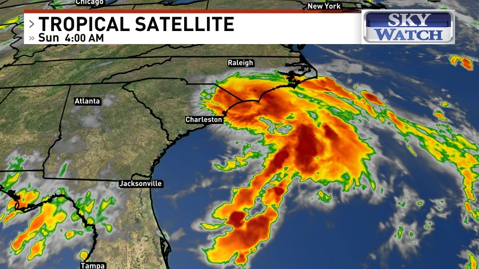
Tropical Storm Chantal makes landfall early Sunday morning along the South Carolina coastline. The storm is producing widespread rainfall totals of 2 to 4 inches, with isolated spots receiving up to 6 inches. Life-threatening rip currents and hazardous surf will continue from northeastern Florida to the Mid-Atlantic as the storm weakens. Residents should remain alert for flooding, isolated tornadoes, and dangerous surf and rip current conditions.
The storm came ashore with maximum sustained winds of 60 mph. The National Hurricane Center estimates Chantal made landfall near Litchfield Beach, South Carolina around 4:00 AM EDT (08 UTC), based on radar and reconnaissance data. Chantal is now moving inland and is expected to weaken rapidly throughout the day. By 5:00 AM, Chantal was located between Georgetown and Myrtle Beach, close to Murrells Inlet.
Main impacts are heavy rain, strong winds, and coastal flooding to parts of the Southeast.
Tropical-storm-force winds extend up to 115 miles from the center. A sustained wind of 47 mph and gust to 56 mph was reported at Springmaid Pier, SC. Gusty winds may lead to downed trees and isolated power outages.
Chantal is producing widespread rainfall totals of 2 to 4 inches, with isolated spots receiving up to 6 inches. The heaviest rainfall will impact eastern and central North and South Carolina, with a continued risk of flash flooding through Monday.
Peak storm surge of 1 to 2 feet is expected from South Santee, SC to Surf City, NC, especially during high tide.
Isolated tornadoes remain possible today across eastern North Carolina and northeastern South Carolina.
Even as the storm weakens, life-threatening rip currents and hazardous surf will continue from northeastern Florida to the Mid-Atlantic.
Chantal is forecast to turn northeast later today, gradually transitioning to a remnant trough by Monday.
Tropical storm warnings are in effect along the Carolina coastline until Tuesday.
Despite weakening winds, residents should remain alert for flooding, isolated tornadoes, and dangerous surf and rip current conditions.
For the latest updates, including localized warnings, visit or check with your local National Weather Service office.
Tropical Storm Chantal made landfall in South Carolina
Tropical Storm Chantal made landfall near Myrtle Beach early Sunday morning. The storm is now pushing inland across far eastern South Carolina. Rainfall totals of 2 to 4 inches are expected, with some areas possibly seeing up to
Sunday 5 a.m. Chantal
Chantal continues to track north at 8 mph, carrying sustained winds of 50 mph.
Sunday 5 a.m. Advisory
Heavy rainbands are moving ashore, keeping the threat of flash flooding very much alive. Rainfall totals of 2 to 4 inches are expected, with some areas possibly seeing up to 6 inches.