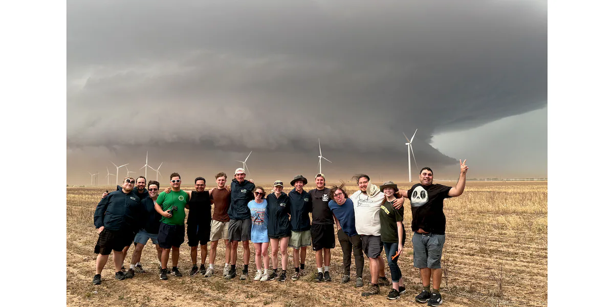
Vermont students travel cross-country to track storms
How did your country report this? Share your view in the comments.
Diverging Reports Breakdown
Vermont will see some snow today, and possible on Christmas Eve. What to know
Light snow is expected in Vermont today. Snow is also predicted to fall on Tuesday, Christmas Eve. Meteorologist: “It’s not a big snow event. It’ll be clearing right out tomorrow” However, meteorologists are saying that there could “be big changes based on how the forecast track evolves” With the anticipated storm, “there’s a lot of model disagreement on this storm,” Meteorologist Tyler Danzig noted. “Wintry weather could cause some big travel disruptions,” AccuWeather said.
“This is expected to be a record-breaking holiday travel season with millions of people driving or flying across the country,” AccuWeather Senior Director of Forecasting Operations Dan DePodwin said in a release this week. “Wintry weather could cause some big travel disruptions.”
When will the snow begin today, and on Tuesday? Here’s what to know.
What’s the outlook for snow today in Vermont?
“Widespread snowfall is expected across this afternoon into tomorrow morning,” according to the National Weather Service branch in Burlington, VT, which added that temperatures will be in 20s today.
“We have some snow showers in the Catskills (New York) moving into Vermont,” Meteorologist Tyler Danzig told USA Today Network on Friday morning. “It’s not a big snow event. It’ll be clearing right out tomorrow.”
The forecast noted that snow could fall harder toward this afternoon, causing travel issues for the evening commute.
“Accumulations will generally be between 1 to 2 inches, with some higher amounts across the western slopes and higher terrain,” according to the National Weather Service.
“It will be more like 3-4 inches in the higher elevations,” Danizig added.
What’s the forecast for Monday, Christmas Eve?
The National Weather Service stated in its forecaster’s discussion that “a (Alberta) Clipper-type system is being presented in most model guidance to move through the region bringing snow showers as early as Monday which could impact holiday travelers.”
“There’s a lot of model disagreement on this storm,” Danzig noted. “But it looks like we will get precipitation on Christmas Eve. The storm should move out by Christmas morning.”
He noted he expects that the storm will be “mostly snow,” as opposed to rain, but said he does not expect too much accumulation from the storm.
However, meteorologists are saying that there could “be big changes based on how the forecast track evolves” with the anticipated storm.
Weekend snow storm Presidents Day weekend in Vermont, New York
A powerful storm system will impact the North Country this afternoon through Sunday night with light snow spreading southwest to northeast this afternoon before intensity increases overnight. Heavy snow, sleet, and freezing rain will continue Sunday bringing widespread difficult travel conditions. Mixed wintry precipitation will taper off to snow showers Sunday night, with cold temperatures and strong gusty winds expected on Monday as the storm system departs. A widespread 8 to 12 inches of snow and sleet is expected for much of the region, with 4 to 8 inches in southern Vermont. Tuesday and Wednesday both look cold and quieter, before another coastal low needs to be watched on Thursday. Follow the NBC5 First Warning Weather team on social media: Chief Meteorologist Tyler Jankoski Facebook | X | InstagramMeteorologist Ben Frechette Facebook |X | Instagrammeteorologist Matt DiLoreto Facebook.
Advertisement Significant weekend storm to disrupt Presidents Day travel in Vermont, New York Widespread disruptive snowfall expected on Sunday, with some mixing Editorial Standards ⓘ
A band of heavier snow has been moving across the region as of Saturday evening, but we expect it to become lighter overnight as the leading edge of the storm battles some dry air. Widespread heavy snow really kicks into gear by daybreak on Sunday. Strong downslope and gap winds, from the east, are likely along west-facing slopes of the Green Mountains Sunday morning and midday. Gusts can reach 50 to 60 mph, at least.The snow likely mixes with or switches to sleet Sunday morning and afternoon from the Tri-Lakes region of New York to central Vermont and south. However, it remains possible that the mixing line makes it north of the Canadian border by later Sunday.For the southern four counties of Vermont, freezing rain takes over midday Sunday. A quarter inch of icing is likely, especially from Rutland to Springfield and points south.Strong wind is known to increase ice accretion during freezing rain. This combination could potentially make the power outage situation worse in southern Vermont.Any mixed precipitation switches back to snow late Sunday evening and starts to slow down after midnight.Strong wind, this time from the west, is likely in southern Vermont Sunday evening/night. East-facing slopes may gust 50 to 60 mph.Monday turns quieter, with lots of clouds and lingering snow in the northern mountains. It will be quite cold, with a continued strong wind from the west! Gusts can reach 40 to 50 mph. Highs reach the teens.A widespread 8 to 12 inches of snow and sleet is expected for much of the region, with 4 to 8 inches in southern Vermont. 18 inches is not out of the question in far northern New York and in the northern Green Mountains if sleet largely stays away and the Monday snow is counted.Tuesday and Wednesday both look cold and quieter, before another coastal low needs to be watched on Thursday.STAY WEATHER-AWAREFor the latest weather coverage for your area, click here. Stay updated with alerts in the myNBC5 app, which you can download here.For the best weather information and Vermont and northern New York’s Certified Most Accurate forecast, watch NBC5 News by streaming at this link.Don’t forget to follow NBC5 News on Facebook, X (formerly Twitter), and Instagram.Follow the NBC5 First Warning Weather team on social media:Chief Meteorologist Tyler Jankoski Facebook | X | InstagramMeteorologist Ben Frechette Facebook | X | InstagramMeteorologist Matt DiLoreto Facebook | XMeteorologist Andrew Grautski Facebook | XMeteorologist Marissa Vigevani Facebook | X
Debby Path: Tropical Storm shifts west bringing track over Vermont. What to expect
Tropical Storm Debby is making its way over the Atlantic. The storm is expected to continue through the East Coast over the weekend. Vermont will feel the effects of Debby this weekend, the NOAA’s latest forecast projects. There is still uncertainty about where the area of heaviest rain will fall, forecasters say. The hurricane center uses only the top four or five highest-performing models to help make its forecasts. The National Weather Service Burlington says the storm is trending westward, which could mean more flooding in the region now that the storm has shifted west. The forecast track does not illustrate the full width of the storm or its impacts, and the center is likely to travel outside the cone up to 33%.
Vermont is likely to feel the impacts of Tropical Storm Debby on Friday, which could include more flooding in the region now that the storm has shifted west.
Though, forecasters caution there is still uncertainty about exactly what to expect.
Tropical Storm Debby is making its way over the Atlantic Wednesday, with concerns of flooding and rainfall in North and South Carolina, according to the National Weather Service’s latest forecast.
After making landfall in Florida on Monday, Debby has killed at least five people so far and continues its track north.
The storm is expected to continue through the East Coast over the weekend. Vermont will feel the effects of Debby this weekend, the NOAA’s latest forecast projects.
Here’s what to know about Debby’s projected impact in Vermont.
Debby expected to bring rainfall to New Hampshire later this week
Although the NOAA had earlier projected several inches of rainfall in Southern New England, overnight the storm shifted west moving that rain to Upstate New York and Vermont. About two to four inches of rain is expected, NOAA said.
“The remnants of Debby will move through the region Friday and Friday night and bring heavy rainfall. Scattered flash flooding is possible,” the National Weather Service Burlington predicted. “There is still uncertainty about where the area of heaviest rain will fall.”
With the storm trending westward, there is a chance that it will continue to move that way, the National Weather Service Burlington wrote in their Area Forecast Discussion, which “means the area of concern may be shifting.”
“The latest forecast has Debby`s remnants crossing near or directly over our forecast area late Friday into early Saturday, with the center potentially being well to our east by Saturday evening. This means a faster end to rainfall on Saturday, with some guidance even indicating that much of the day will be dry, especially from the Champlain Valley westward,” the Area Forecast Discussion reads.
Vermont, they added, remains particularly sensitive to flooding.
Where is Tropical Storm Debby now?
Debby is expected to cause flooding in portions of North and South Carolina Wednesday through Friday, the NOAA projects.
“Tropical Storm Debby is forecast to restrengthen a bit and re-curve toward the Southeast today before making landfall along the central South Carolina coast tonight,” the NOAA said.
Tropical Storm Debby tracker
This forecast track shows the most likely path of the center of the storm. It does not illustrate the full width of the storm or its impacts, and the center of the storm is likely to travel outside the cone up to 33% of the time.
Tropical Storm Debby spaghetti models
Illustrations include an array of forecast tools and models, and not all are created equal. The hurricane center uses only the top four or five highest-performing models to help make its forecasts.
How long does hurricane season last?
Hurricane season runs from June 1 to Nov. 30 in New England.
Hurricanes don’t stop at the coast – these mountain towns know how severe inland flood damage can be, and they’re watching Helene
Hurricanes Frances, Ivan and Jeanne all brought excessive rain to western North Carolina in the span of a few weeks. Storms like these are a reminder to mountain communities and other inland regions across the U.S. that they also need to be ready for hurricane season. As the climate warms, the air can hold more moisture, meaning tropical cyclones can deliver more rain as well as thunderstorms – as Helene is expected to do in 2024. The French Broad River in Western North Carolina rose to 23.1 feet – a record more than 5 feet higher than any crest before or since – during the 2004 storms. The Santee River, which flows seaward from the Blue Ridge Mountains, destroyed some 700,000 acres of crops in South Carolina. The importance of rail transport and the limited amount of land for commercial and industrial uses compelled reconstruction near the river in 1930. Congress approved a flood control study in 1930, but no structural protections were built. Revised building codes and land use restrictions to reduce flood impacts came much later.
Yet, the remnants of several hurricanes have swept through this region over the years, sending rivers in the region raging out of their banks.
Hurricane Helene could add to that history. With the huge storm on track to bring heavy rain to parts of North Carolina starting Sept. 26, 2024, Gov. Roy Cooper issued a state of emergency, warning of flash flooding, high winds and landslides, particularly in the western mountains.
Storms like these can be extremely destructive. In September 2004, the remnants of Hurricanes Frances, Ivan and Jeanne all brought excessive rain to western North Carolina in the span of a few weeks, overwhelming the French Broad and other rivers in the Asheville area.
Western North Carolina’s history is just one example of the inland risks from tropical cyclones. Vermont was caught off guard by Tropical Storm Irene in 2011, which swept away hundreds of homes. The remnants of Hurricane Ida in 2021 caused nearly US$84 billion in damage as its heavy rains caused flooding in states from Louisiana to New York. In 1998, Tropical Storm Charley traveled nearly 200 miles up the Rio Grande Valley, quickly flooding the dry Texas landscape, with devastating consequences.
I am a historical geographer who researches flood hazards and how communities both exacerbate the risk and respond. Storms like these are a reminder to mountain communities and other inland regions across the U.S. that they also need to be ready for hurricane season.
Tough lessons from North Carolina’s mountains
Western North Carolina provides an important case study of a hurricane season risk that might seem rare but can be catastrophic. It also shows how some communities are starting to respond.
In July 1916, the Asheville area was deluged by back-to-back tropical storms that tore apart river bridges and roads, washed away businesses and left large parts of the city under water.
The first tropical storm made landfall in Mississippi and meandered into the Southern Appalachians. As it lingered over western North Carolina, 6 to 10 inches of rain fell in the mountains, running off into creeks and then into rivers, including the French Broad.
A week later, a second tropical storm moved ashore, this time in South Carolina and headed for the already saturated ground of the French Broad River basin. It dropped 12 to 15 inches near Brevard. Weather Bureau forecasters wrote that saturated soils allowed 80% to 90% of the new precipitation to run off the mountains into French Broad River tributaries.
At Asheville, the river rose to 23.1 feet – a record more than 5 feet higher than any crest before or since. The water washed out bridges and damaged most businesses and industries on the floodplain.
Dozens of people died in the flooding, and commerce was disrupted for weeks. The Santee River, which flows seaward from the Blue Ridge Mountains, destroyed some 700,000 acres of crops in South Carolina.
Responses to the 1916 storms weren’t enough
After the storms, there was talk of replacing some devastated structures with flood-proof buildings. However, the importance of rail transport and the limited amount of land for commercial and industrial uses compelled reconstruction near the river. Congress approved a flood control study in 1930, but no structural protections were built. Revised building codes and land use restrictions to reduce flood impacts came much later.
Then, in September 2004, the region was hit with back-to-back tropical storm disasters again.
Hurricane Frances made landfall on Florida and eventually climbed the Blue Ridge Mountains into Western North Carolina. Remnants of the hurricane dumped 8 to 12 inches of rain near Asheville. Black Mountain received 14.6 inches, which flowed into a French Broad River tributary, triggering widespread flooding where the rivers meet. The torrent severed a water main and cut off drinking water to Asheville residents.
Shortly after Frances hit, Hurricane Ivan roared ashore in Alabama and moved inland, bringing 4 to 12 more inches of rain to the French Broad basin over three days. Saturated soils on the mountain slopes lost their grip and caused numerous landslides, and portions of Asheville and Brevard flooded. Remnants of Hurricane Jeanne brought even more rain to western North Carolina a few days later.
Using the past to plan for the future isn’t enough
Traditionally, officials planning for hazards like hurricanes have relied on records of past events to guide their decisions. However, this approach assumes that the climate is stable, and that just isn’t the case.
As the climate warms, the air can hold more moisture, meaning tropical cyclones – as well as inland thunderstorms – can deliver more rain.
This can be particularly troublesome as giant storms move inland and cause streams and rivers to flood. Back-to-back storms can be even more destructive. New development in areas that were once unlikely to flood may be more susceptible as the climate heats up.
Some communities are starting to consider how future risk might worsen.
In the Asheville area, Buncombe County’s hazard mitigation plan now explicitly recognizes hurricane risks and acknowledges that “future occurrences are likely.”
Following the 2004 flood, the county modified its use of a water supply reservoir to include storage of floodwaters, and it now requires new buildings constructed in areas inundated in 2004 to be elevated 2 feet above the base flood elevation. The city of Brevard, 30 miles south of Asheville, restricted construction in flood-prone areas to limit future losses.
Asheville has created green spaces along the French Broad River and has made efforts to enlarge stormwater retention behind dams on tributaries. But altering stormwater drainage systems is costly when the existing systems were designed to meet historical rainfall levels, rather than the scale of rainfall that will accompany climate change.
Extreme weather events, including mountain and inland flooding, are becoming a frequent problem across the U.S., and I believe they demand greater consideration in disaster planning at all levels. For communities, preparing for these future risks requires learning from past floods but also recognizing that future storms may produce flooding that goes beyond the scale of anything seen before.
This article, originally publisheed May 29, 2024, has been updated with the Hurricane Helene forecast, and to correct the date of Hurricane Ida.
New series of winter storms lining up to bring more snow and ice to the nation’s midsection
The first storm will form in the Central US Monday night and ramp up as it heads east. It will bring snow and freezing rain to parts of the Appalachian Mountains, mid-Atlantic and southern portions of the Northeast Tuesday through Wednesday. The second storm will hit the Central Plains Tuesday evening through Wednesday, where heavy snow is possible for cities like Kansas City. The current forecast for the second storm calls for rainfall to be the most likely form of precipitation for the major metropolitan cities across the Northeast. Below-normal temperatures are likely to be recorded across much of the continental US over the next few weeks, the weather service said. This combination of active weather and prolonged cold may cause a continued stretch of winter disruption for many Americans. The National Weather Service has issued a winter storm watch for much of northern Kansas and Missouri for Wednesday and Thursday. The storm watch is in effect from 9 p.m. Tuesday to 6 p.M. CT Wednesday and could be extended into Thursday, with snowfall possible in Washington, DC and New York City.
As the Midwest and Northeast dig out from back-to-back winter storms, new systems are building and are expected to dump more snow from the middle of the country to the East Coast this week.
Plenty of cold air remains in place to the north, helping to set the stage for a wide band of wintry mix and snow, according to the Weather Prediction Center.
The first storm will form in the Central US Monday night and ramp up as it heads east, bringing snow and freezing rain to parts of the Appalachian Mountains, mid-Atlantic and southern portions of the Northeast Tuesday through Wednesday.
The worst conditions are expected across the Appalachian Mountains from Northwestern North Carolina into Southwestern Virginia, with ice over 0.25 inches expected, which could cause downed tree limbs, power outages and travel headaches.
Snow is more likely through the I-95 corridor from Richmond to Philadelphia, including Washington, DC, which is already under a winter storm watch Tuesday into Wednesday and could see 4-6 inches.
The district has already seen more snowfall this year than the last two years combined, with more on the way.
Then, on the heels of the first storm of the week, another will move in quickly behind it.
The storm will start in the Central Plains Tuesday evening through Wednesday, where heavy snow is possible for cities like Kansas City, while Oklahoma City and Springfield, Missouri, could see freezing rain.
A winter storm watch for Wednesday and Thursday has already been posted across much of northern Kansas and Missouri. Snowfall across the I-70 corridor could exceed 5 inches, and Kansas City could potentially see 4-8 inches of snowfall.
This storm’s effects will spread to the Great Lakes for Wednesday and could bring snowfall to cities like Chicago and St. Louis. The current forecast for the second storm calls for rainfall to be the most likely form of precipitation for the major metropolitan cities across the Northeast.
Kansas Gov. Laura Kelly issued a verbal state of disaster emergency proclamation on Sunday due to incoming winter weather expected to hit the state as early as Monday evening.
“As I did during past storms, I urge all Kansans to take measures to make sure their families are ready by making a home emergency kit and emergency plan,” Kelly said.
Major cities expecting more storms
Below-normal temperatures are likely to be recorded across much of the continental US over the next few weeks, the weather service said. This combination of active weather and prolonged cold may cause a continued stretch of winter disruption for many Americans.
Here are the projected weather impacts for major cities as the storms move across the country. The first storm will affect the Mid-Atlantic and Northeast while the second will affect the Central US:
Oklahoma City : The forecast calls for up to .25 inches of ice Tuesday night through Wednesday late morning. Peak icing is expected between midnight and 6 a.m.
: The forecast calls for up to .25 inches of ice Tuesday night through Wednesday late morning. Peak icing is expected between midnight and 6 a.m. Kansas City : A Winter Storm Watch will be in effect from 9 p.m. CT Tuesday to 6 p.m. CT Wednesday. Snowfall of 4-8 inches is possible. Peak snowfall will be Wednesday from midnight to 5 p.m.
: A Winter Storm Watch will be in effect from 9 p.m. CT Tuesday to 6 p.m. CT Wednesday. Snowfall of 4-8 inches is possible. Peak snowfall will be Wednesday from midnight to 5 p.m. St Louis : The forecast calls for snowfall of 1-3 inches Wednesday, with peak snowfall expected between noon and 6 p.m.
: The forecast calls for snowfall of 1-3 inches Wednesday, with peak snowfall expected between noon and 6 p.m. Chicago : The forecast calls for snowfall of at least an inch beginning Wednesday afternoon and lasting into Thursday.
: The forecast calls for snowfall of at least an inch beginning Wednesday afternoon and lasting into Thursday. Washington, DC : A Winter Storm Watch will be in effect from 1 p.m. Tuesday until 7 a.m. Wednesday. Snowfall of 4-6 inches is possible. Peak snowfall will be from 2 p.m. Tuesday to 5 a.m. Wednesday.
: A Winter Storm Watch will be in effect from 1 p.m. Tuesday until 7 a.m. Wednesday. Snowfall of 4-6 inches is possible. Peak snowfall will be from 2 p.m. Tuesday to 5 a.m. Wednesday. Philadelphia : The forecast calls for 2-4 inches of snow Tuesday afternoon to Wednesday night, so alerts could be posted soon.
: The forecast calls for 2-4 inches of snow Tuesday afternoon to Wednesday night, so alerts could be posted soon. New York City: The forecast calls for 1-2 inches of snow Tuesday night.
A third storm is set to hit the West Coast late Wednesday, bringing a threat of heavy rain to Southern California on Thursday. In Ventura Country, the rain could trigger life-threatening debris flows in burn scar areas from January’s wildfire.
The Weather Prediction Center has issued a level 2 out of 4 risk for excessive rainfall, threatening more than 34 million people across Central and Southern California Thursday, including Sacramento, the San Francisco Bay Area and Los Angeles.
By the weekend, the storm is expected to move east, bringing additional weather risks to the Central and Eastern US.
People worked to clear sidewalks and roads blanketed by snow in New York Sunday. Seth Harrison/The Journal News/USA Today Network
Earlier double-barreled storm brought heavy snow
Parts of the Northeast woke up to more than a foot of snow Sunday morning, as a fast-moving winter storm, packing snow, sleet and ice, sped across the Midwest into the Northeast over the weekend.
More than 15 million people from the Midwest to the Northeast were under winter alerts while the storm moved through. Those warnings have now expired. While the snow has mostly come to an end, travelers are experiencing delays due to the weather, and officials are warning people to watch out for snow-covered, slippery roads.
As fans made their way into New Orleans for Super Bowl Sunday, dense fog in the area caused reduced visibility in several locations, the National Weather Service warned, urging drivers to exercise extreme caution on roadways.
More than 400 flights into or out of the US were canceled Sunday, with another 3,800 flights delayed, according to the flight tracking website FlightAware.
Parts of New York state, Wisconsin and Vermont received more than a foot of snow since it began falling Saturday, while states from Minnesota to Maine saw between 2.5 to 11 inches.
Snow-covered and slippery roads could cause dangerous travel conditions, and areas with heavy ice could experience power outages and minor tree damage, the weather service said.
In New York and Boston, crews worked Sunday to clear snow and ice from the roads. Boston had 41,000 tons of salt are on hand to treat streets blanketed by heavy snow, the city previously announced.
Drivers made their way down snowy roads in Massachusetts Sunday. Scott Eisen/Getty Images
The storm system moved in two rounds: The first brought heavy snow to the Midwest on Saturday afternoon, followed by significant snowfall in parts of the Northeast, coupled with icy conditions in the Appalachians.
Along with the snowfall in the Midwest and Northeast, the storm brought icy conditions to the Appalachians.
Colder temperatures are coming
Three more systems are on the horizon through this weekend, with another Arctic blast expected to push temperatures 10 to 20 degrees below seasonal norms across the Northeast. Meteorologists attribute this active pattern to the positioning of the jet stream, which is funneling storms across the northern US.
The jet stream, essentially a river of air in the atmosphere that storms flow through, is locked in an almost perfect line from west to east and will continue to funnel fast-moving storms across the northern tier of the Lower 48.
This pattern has been responsible for maintaining lower-than-average temperatures across much of the country this winter. New storms are expected to arrive every few days until the jet stream shifts – something that might not happen until the second half of February.
This weekend’s storms are just part of what forecasters expect will be an active February for winter weather.
CNN Meteorologist Mary Gilbert, Dalia Faheid, Karina Tsui and Hanna Park contributed to this report.
Source: https://www.wcax.com/2025/07/21/vermont-students-travel-cross-country-track-storms/